place

Hopton Incline

Rail transport in DerbyshireUse British English from January 2017
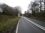
Hopton Incline, Cromford and High Peak Railway 1964

The Hopton Incline was the steepest stretch of conventional, adhesion-worked standard gauge railway in the UK. The incline was situated in sparsely populated, exposed limestone uplands in the Peak District of Derbyshire, England. It is possible that steeper stretches were to be found in sidings, but the Hopton Incline was on the former Cromford and High Peak Railway's single-track main line as inherited by British Railways.

Excerpt from the Wikipedia article Hopton Incline (License: CC BY-SA 3.0, Authors, Images).

Hopton Incline
Brassington Lane, Derbyshire Dales

Geographical coordinates (GPS) Address Nearby Places
placeShow on map

Wikipedia: Hopton InclineContinue reading on Wikipedia

Geographical coordinates (GPS)

Latitude Longitude
N 53.0883697 ° E -1.6219715 °
placeShow on map

Address

Brassington Lane

Brassington Lane
DE4 4NY Derbyshire Dales
England, United Kingdom
mapOpen on Google Maps

Hopton Incline, Cromford and High Peak Railway 1964
Share experience

Nearby Places

Hopton Hall
Hopton Hall

Hopton Hall is an 18th-century country house at Hopton, near Wirksworth, Derbyshire. It is a Grade II listed building. The Manor of Hopton, anciently the seat of the de Hopton family, was acquired by the Gell family in 1553 by Ralph Gell (1491–1564) who also purchased lands at Darley Abbey and Rocester.John Gell was created a baronet in 1642 (see Gell baronets). The Baronetcy was extinct in 1719 and the estate passed to John Eyre in 1732 via his mother Katherine Gell, daughter of 2nd baronet John Gell, at which point Eyre added the surname of Gell. The house has its origins in the 16th century when it was built by Thomas Gell as a two-storey, three-bay manor house. It was extended and remodelled by Philip Eyre Gell in the late 18th century. The north entrance front has three storeys and seven bays, flanked by tower wings with pyramidal roofs.Notable members of the Gell family include the religious patron Katherine Gell, Philip Gell's younger brother, Admiral John Gell and Philip's son Sir William Gell.Philip Gell's daughter and heir married William Pole Thornhill MP, on whose death the estate passed to his kinsman Henry Pole, later known as Henry Chandos-Pole-Gell (High Sheriff of Derbyshire) in 1886. The estate of some 3,700 acres (15 km2) was broken up in the 20th century, a major part being sold to a water authority for the creation of Carsington Reservoir. The house itself was put up for auction in 1989, passing out of the family. The present owner is Sir Bill Thomas and his family, a former senior vice president of Hewlett-Packard Europe who was drafted in by Ed Miliband to chair Labour's "small business taskforce". Thomas and his wife Julie have opened their formal gardens and lake to the public during February and early March for the woodland Snowdrop Walk and during the summer to the Rose Garden. Both periods allow access to the 30 acres (12 ha) of grounds and 2 km (1.2 mi) of signposted paths.The document collection of the Gell family of Hopton Hall is held by the Derbyshire Record Office.

Callow, Derbyshire
Callow, Derbyshire

Callow is a village and a civil parish in the Derbyshire Dales District, in the English county of Derbyshire. At the 2011 Census the population of the civil parish was less than 100. Details are included in the civil parish of Kirk Ireton. It is near the small town of Wirksworth and the reservoir Carsington Water. Callow is recorded as Caldelawe in 1086 as having two caracutes of land as a berewick (supporting farm) of nearby Wirksworth. Callow Hall (not to be confused with Callow Hall at Ashbourne) is a moated site with a seventeenth century gritstone double-bayed main farmhouse building constructed over a thirteenth century undercroft.Callow was one of the manors of the Duchy of Lancaster in the Middle Ages and was involved in a dispute between the Duchy and the Stathams of Morley, who had a tenancy at Callow. "30 mares, 30 Ox, 30 cows and 20 bullocks worth 100 marks were taken from Duchy of Lancaster lands at Morley, Callow and Wirksworth and (the Stathams) cut down John of Gaunt’s trees to the value of £100, dug in his mine, assaulted his free tenants and serfs, destroyed their tenements and practiced such oppressions at Ralph Statham’s court that many of his (John of Gaunts) tenants had left". Ralph Statham died on 13 June 1380 but his sons carried on their feud with the Duchy. On 20 June 1381 Philip of Okeover, one of John of Gaunt's knights with his retainers, struck back at the Stathams with an attack on their lands at Callow. This feud continued in an on-off kind of way throughout the 1380s, as it is recorded again, in 1387. Callow was also one of the lead ore producing manors close to Wirksworth and in 1822 lead miners sinking a shaft at the Dream Mine, on Stainsborough Hill at Callow, discovered the remains of a prehistoric woolly rhinoceros.

Harboro' Rocks
Harboro' Rocks

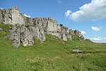
Harboro' Rocks (or Harborough Rocks) is a dolomitic limestone hill near the village of Brassington in the Derbyshire Peak District. The summit is 379 metres (1,243 ft) above sea level with views across to Carsington Water. Harboro' Cave is a natural cavern in the rocks where archaeologists have found evidence of human occupants since the Ice Age. Satirist author Daniel Defoe reported in his book Tour thro' the whole Island of Great Britain (published in 1726) that a poor family of seven was living in the cave. Defoe described how the father was a lead miner and was "lean as a skeleton, pale as a dead corps" but that they "seemed to live very pleasantly". The cave is a protected Scheduled Monument. There is a settlement site and chambered cairns nearby. The Golconda lead mine, on the north east side of the hill, was part of the Gell family's Griffe Grange mining liberty, which ran from the summit of Harboro' Rocks to Via Gellia. The mine dates back to the 1700s and the mine shaft is over 100 metres (330 ft) deep. Golconda is a name used for wealthy mines, after the famous Indian Golconda diamond mine. The mine's tunnels enter natural caverns such as the Great Shack. After closing in 1913, the mine was reopened in 1915 to mine baryte until 1953. Furnace-lining bricks have been manufactured from local quartz sand at Harborough brickworks for many years (recently by Hobens Minerals and previously by Swan Ratcliffe).Most of the White Peak is a carboniferous limestone plateau. This unusual jagged outcrop of dolomitic limestone offers interesting buttresses, arêtes and pinnacles for rock climbing (and some easy bouldering) with over 100 graded routes.Nearby Rainster Rocks is another dolomitic limestone crag and is the site of a Romano-British settlement and field system from the 3rd century. The remains include enclosures with walls made of upright boulders (orthostats) and earthwork terraces. Excavations have found pottery fragments, metalwork and coins. The site is a listed ancient Scheduled Monument. Rainster Rocks was also a popular rock climbing location (with over 80 graded routes) and has been climbed for over 100 years. However the landowners have imposed an outright ban on climbing there since 2018.The land around Harboro' Rocks is designated as "Open Access" land for the public, following the Countryside and Rights of Way Act 2000.The High Peak Trail and the Midshires Way footpaths follow the same route along the south west side of the hill. The Limestone Way long-distance footpath passes the north west side of the hill.