place

Brown Stocking Mill Historic District

Essex County, Massachusetts Registered Historic Place stubsHistoric districts on the National Register of Historic Places in MassachusettsIpswich, MassachusettsNRHP infobox with nocatNational Register of Historic Places in Ipswich, Massachusetts
Use mdy dates from August 2023
39 Brownville, Ipswich MA

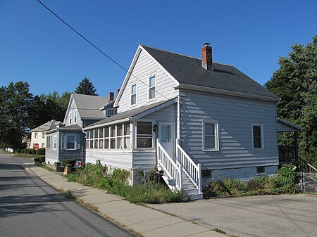
The Brown Stocking Mill Historic District in Ipswich, Massachusetts encompasses the (now demolished) mill building of Harry S. Brown's stocking-making factory, and associated mill worker housing Brown had built. Brown, a supervisor at the Ipswich Mills, established his company in 1906, constructed a factory on Brownville Avenue, and built a series of worker housing units on Brownville and several nearby streets. The historic district was listed on the National Register of Historic Places in 1996. It includes properties at 24—32 Broadway Avenue, 3—41 Brownville Avenue, 10 Burleigh Avenue, 3—5 Burleigh Place, and 35—47 Topsfield Road.

Excerpt from the Wikipedia article Brown Stocking Mill Historic District (License: CC BY-SA 3.0, Authors, Images).

Brown Stocking Mill Historic District
Bailey Street,

Geographical coordinates (GPS) Address Nearby Places
placeShow on map

Wikipedia: Brown Stocking Mill Historic DistrictContinue reading on Wikipedia

Geographical coordinates (GPS)

Latitude Longitude
N 42.677222222222 ° E -70.846944444444 °
placeShow on map

Address

Bailey Street 5

Massachusetts, United States
mapOpen on Google Maps

39 Brownville, Ipswich MA
Share experience

Nearby Places

High Street Historic District (Ipswich, Massachusetts)

The High Street Historic District is a predominantly residential historic district in Ipswich, Massachusetts. It encompasses the oldest section of High Street, which was laid out when Ipswich was founded in 1633. The district runs for four blocks from the junction with Town Farm Road and the railroad right-of-way in the west, to North Main Street in the east. The street was for several centuries part of the principal thoroughfare through the town, but became sidelined by the construction of Central Street in 1871, which bypassed traffic off most of this stretch of High Street.Ipswich was from its earliest days an important transit stop, and High Street was the location of its inns for travelers. It was also where courts met when judges rode the circuit. In the 18th century small industrial shops also populated the street, and some of these led to the building of larger textile firms elsewhere. When Central Street was built just south of High Street, the street began to acquire a more distinctly residential character, which it retains to this day.The district contains more than thirty structures built before 1750, many of which retain First Period and Georgian styling. Some of the more interesting houses include that of John Caldwell, built c. 1660 on the site of Governor Simon Bradstreet's original 1630s house, the c. 1770s town jail, which was converted into a Greek Revival house in the 19th century, and the c. 1727 house of Reverend Nathaniel Rogers. One of the more unusual later buildings included on the district is a Stick Victorian at 12 High Street.The district was listed on the National Register of Historic Places in 1980.

South Green Historic District (Ipswich, Massachusetts)

The South Green Historic District encompasses one of the oldest central civic parts of Ipswich, Massachusetts. The town's South Green was laid out in 1686, and is now the heart of a collection of historic properties dating from the 17th to the 19th century. The centerpiece of the district is the green itself, and its most notable associated property is the John Whipple House, a National Historic Landmark and museum. The district boundaries extend from the junction of South Main and Elm Streets, southward past the green to where County Road (Massachusetts Route 1A) crosses Saltonstall's Creek.Ipswich voted to establish the South Green in 1686, after which it was used as a common grazing area, and as a training ground for the local militia. It was also the site of Ipswich's earliest school buildings, which even predated the establishment of the green as a common area. The first schoolhouse was built in the area in 1652; it was moved to the Meetinghouse Green in 1704, at which time private education continued in the area. A public school was again introduced to the South Green area in 1794, which became the English High School from 1836 to 1874.Most of the surviving structures in the district are houses. The oldest is the c. 1653 Whipple House, which was moved to the area in the 1930s. The green is flanked by buildings dating through the 19th century, in a variety of styles. The predominant styles are Georgian, Federal, and Greek Revival, although there are several later Victorian properties. The district was listed on the National Register of Historic Places in 1980.