James Island (British Columbia)
Ghost towns in British ColumbiaIslands of the Gulf IslandsPages with non-numeric formatnum argumentsPopulated places in the Capital Regional DistrictUse Canadian English from January 2023
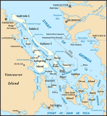
James Island, one of British Columbia's Gulf Islands, lies in Haro Strait between Sidney Island and the coast of Vancouver Island near Sidney, British Columbia. James Island is approximately 2.4 km (1.5 mi) from the coast of Vancouver Island, and 145 km (90 mi) from Seattle, Washington. James Island has an elevation of 145 metres (476 feet) above sea level at its highest point, and has a total land-mass of 315 hectares (780 acres). There are sea-cliffs on the Southern, Western, and Eastern shores of this island. The Southern sea-cliffs are the highest.
Excerpt from the Wikipedia article James Island (British Columbia) (License: CC BY-SA 3.0, Authors).James Island (British Columbia)
Southern Gulf Islands Electoral Area
Geographical coordinates (GPS) Address Nearby Places Show on map
Geographical coordinates (GPS)
| Latitude | Longitude |
|---|---|
| N 48.604722222222 ° | E -123.34944444444 ° |
Address
V8M 1T7 Southern Gulf Islands Electoral Area
British Columbia, Canada
Open on Google Maps


