Sidney Island
Cowichan Land DistrictGreater VictoriaIslands of the Gulf IslandsUse Canadian English from January 2023
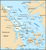
Sidney Island is one of the southern Gulf Islands located between the southwest coast of British Columbia, Canada and Vancouver Island, BC, near James Island. Sidney Island has an elevation of 77 meters (252 feet 8 inches) above mean sea level at its highest point. It is located just east of the town of Sidney which is on the east coast of the Saanich Peninsula. Sidney Island is a part of the Capital Regional District, while its land titles are legally described in the Cowichan Land District. In 1859 Captain Richards named the island for Frederick W. Sidney, who, like Richards served in the survey branch of the Royal Navy.: 243
Excerpt from the Wikipedia article Sidney Island (License: CC BY-SA 3.0, Authors).Sidney Island
Southern Gulf Islands Electoral Area
Geographical coordinates (GPS) Address Nearby Places Show on map
Geographical coordinates (GPS)
| Latitude | Longitude |
|---|---|
| N 48.616666666667 ° | E -123.3 ° |
Address
Southern Gulf Islands Electoral Area
Southern Gulf Islands Electoral Area
British Columbia, Canada
Open on Google Maps


