place

Cotmanhay

Borough of ErewashDerbyshire geography stubsVillages in Derbyshire
Cotmanhay park
Cotmanhay park

Cotmanhay is a village in Derbyshire, England, and used to be a Viking settlement. Cotmanhay is in the Erewash Borough Council area, north of Ilkeston. Recently a flint implement was found at the edge of Cotmanhay Wood, indicating that the area was inhabited several thousand years BC. The Erewash ward population at the 2011 Census was 4,531.The neighbourhood's two main industries were textiles and coal mining, the latter from 1848 until 1880. The 2019 Multiple deprivation index found the area around Skeavingtons Lane to be the most deprived area in Derbyshire.

Excerpt from the Wikipedia article Cotmanhay (License: CC BY-SA 3.0, Authors, Images).

Cotmanhay
Ebenezer Street, Erewash

Geographical coordinates (GPS) Address Nearby Places
placeShow on map

Wikipedia: CotmanhayContinue reading on Wikipedia

Geographical coordinates (GPS)

Latitude Longitude
N 52.98278 ° E -1.3087 °
placeShow on map

Address

Ebenezer Street 37A
DE7 8JG Erewash
England, United Kingdom
mapOpen on Google Maps

Cotmanhay park
Cotmanhay park
Share experience

Nearby Places

Ilkeston Town railway station

Ilkeston Town railway station was a railway station which served the town of Ilkeston in Derbyshire, England. It was opened in 1847 by the Midland Railway. This station was connected to the Erewash Valley Line by a short branch from Ilkeston Junction, the route of which roughly followed the present Millership Way and which was served by horse-drawn railway carriages for some years.By 1853, three trains were running daily each way between Nottingham and Ilkeston via Long Eaton. However, local newspapers contain many letters of complaint in the 1850s and 1860s regarding the poor standard of waiting rooms and other facilities at the local stations and even about the rudeness of the staff. Some of the Midland Railway's Directors, their General Manager and Engineer visited Ilkeston in 1860 to discuss rail users’ concerns, although little seems to have been accomplished from the visit.The original station, opened on 6 September 1847 and named Ilkeston, was closed on 2 May 1870 but remodelled in response to the arrival of the Great Northern Railway (Great Britain) Derbyshire Extension line through its station later known as Ilkeston North. The station, now named Ilkeston Town, re-opened on 1 July 1879.It carried a shuttle service from Ilkeston Junction which was never particularly popular since the GNR provided a direct main line service. Some services were also provided to Nottingham and Chesterfield From 1882 the former were routed along the Bennerley Junction route to Basford, with six services a day, but they ended at the beginning of the First World War.In the Grouping of all lines (into four main companies) in 1923 the station became part of the London, Midland and Scottish Railway . The station closed to passengers on 10 July 1950, having been open on a restricted basis since 16 June 1947, and goods operations had ceased by 1960. The tracks were lifted and the footbridge removed. The site is now occupied by a roundabout at the end of Ilkeston's Chalons Way by-pass and a large Tesco supermarket.

Bennerley Viaduct
Bennerley Viaduct

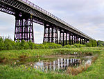
Bennerley Viaduct (originally Ilkeston Viaduct and known informally as the Iron Giant) is a former railway bridge, now a foot and cycle bridge, between Ilkeston, Derbyshire, and Awsworth, Nottinghamshire, in central England. It was completed in 1877 and carried the Great Northern Railway's (GNR) Derbyshire Extension over the River Erewash, which forms the county boundary, and its wide, flat valley. The engineer was Samuel Abbott, who worked under Richard Johnson, the GNR's chief engineer. The site required a bespoke design as the ground would not support a traditional masonry viaduct due to extensive coal mining. The viaduct consists of 16 spans of wrought iron, lattice truss girders, carried on 15 wrought iron piers which are not fixed to the ground but are supported by brick and ashlar bases. The viaduct is 60 feet (18 metres) high, 26 feet (8 metres) wide between the parapets, and over a quarter of a mile (400 metres) long. It was once part of a chain of bridges and embankments carrying the railway for around two miles (three kilometres) across the valley but most of its supporting structures were demolished when the line closed in 1968. The only similar surviving bridge in the United Kingdom is Meldon Viaduct in Devon. The viaduct opened in January 1878. Its working life was uneventful except for minor damage inflicted by a Zeppelin bombing raid during the First World War. Plans to demolish the viaduct failed because of the cost of dismantling the ironwork and it became a listed building in 1974. After closure, the viaduct received little maintenance and fell into disrepair. Railway Paths, a walking and cycling charity, acquired it for preservation in 2001 but work faltered due to a lack of funding. The viaduct was listed on the Heritage at Risk Register in 2007 and the 2020 World Monuments Watch for its condition and lack of use. A detailed survey was undertaken in 2016 and funding for restoration work was secured in 2019. The work included rebuilding an embankment to allow step-free access. It opened to the public as part of a cycling and walking route in January 2022.