Chatham Historic Dockyard

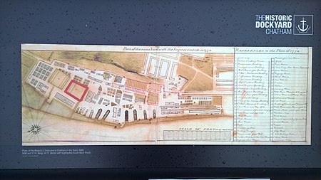
The Historic Dockyard Chatham is a maritime museum on part of the site of the former royal/naval dockyard at Chatham in Kent, South East England. Chatham Dockyard covered 400 acres (1.6 km²) and was one of the Royal Navy's main facilities for several hundred years until it was closed in 1984. After closure the dockyard was divided into three sections. The easternmost basin was handed over to Medway Ports and is now a commercial port. Another slice was converted into a mixed commercial, residential and leisure development. 80 acres (324,000 m²), comprising the 18th-century core of the site, was transferred to a charity called the Chatham Historic Dockyard Trust and is now open as a visitor attraction. It claims to be the world’s most complete dockyard of the Age of Sail.
Excerpt from the Wikipedia article Chatham Historic Dockyard (License: CC BY-SA 3.0, Authors, Images).Chatham Historic Dockyard
Khartoum Road,
Geographical coordinates (GPS) Address Phone number Website External links Nearby Places Show on map
Geographical coordinates (GPS)
| Latitude | Longitude |
|---|---|
| N 51.3968 ° | E 0.5294 ° |
Address
The Historic Dockyard Chatham (Chatham Historic Dockyard)
Khartoum Road
ME4 4TZ
England, United Kingdom
Open on Google Maps


