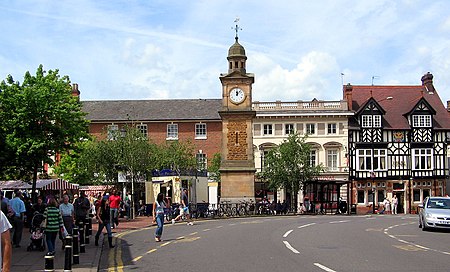
Rugby, Warwickshire

Rugby is a market town in eastern Warwickshire, England, close to the River Avon. At the 2021 census its population was 78,117, making it the second-largest town in Warwickshire. It is the main settlement within the larger Borough of Rugby, which had a population of 114,400 in 2021.Rugby is situated on the eastern edge of Warwickshire, near to the borders with Leicestershire and Northamptonshire. Rugby is the most easterly town within the West Midlands region, with the nearby county borders also marking the regional boundary with the East Midlands. It is 83 miles (134 km) north of London, 30 miles (48 km) east-southeast of Birmingham, 11.5 miles (18.5 km) east of Coventry, 18 miles (29 km) north-west of Northampton, and 19 miles (31 km) south-southwest of Leicester. Rugby became a market town in 1255. In 1567 Rugby School was founded as a grammar school for local boys, but by the 18th century it had gained a national reputation as a public school. The school is the birthplace of Rugby football which, according to legend, was invented in 1823 by a Rugby schoolboy named William Webb Ellis. Rugby remained a small and fairly unimportant town until the mid-19th century, when a major railway junction was established there, which spurred the development of industry, and the rapid growth of population.
Excerpt from the Wikipedia article Rugby, Warwickshire (License: CC BY-SA 3.0, Authors, Images).Rugby, Warwickshire
Lawrence Sheriff Street,
Geographical coordinates (GPS) Address Phone number Website Nearby Places Show on map
Geographical coordinates (GPS)
| Latitude | Longitude |
|---|---|
| N 52.37 ° | E -1.26 ° |
Address
Rugby School
Lawrence Sheriff Street
CV22 5EJ , New Bilton
England, United Kingdom
Open on Google Maps


