place

Sir Lowry's Pass

Elgin, Western CapeMountain passes of the Western CapeN2 road (South Africa)
Hottentots Holland
Hottentots Holland

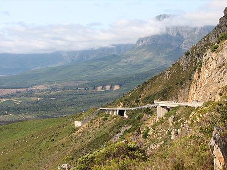
Sir Lowry's Pass is a mountain pass on the N2 national road in the Western Cape province of South Africa. It crosses the Hottentots Holland Mountains between Somerset West and the Elgin valley, on the main route between Cape Town and the Garden Route. A railway line also crosses the mountain range near this point. The pass is 4 lanes wide and is subject to heavy traffic, especially at the start and end of holiday periods when many people travel in and out of the Cape Town area, and is sometimes seen as an accident black spot.The summit of the pass is at 460 m. There is a viewpoint at this point which is also used as a paragliding launch point. Baboons are often seen in this area. The top of the pass was formerly the start of the Boland Hiking Trail, but this section of the trail was closed after a number of deaths due to the difficult hiking conditions. On the Grabouw side, the road passes the Steenbras Dam. Sir Lowry's Pass Village is situated near the base of the pass.

Excerpt from the Wikipedia article Sir Lowry's Pass (License: CC BY-SA 3.0, Authors, Images).

Geographical coordinates (GPS)

Latitude Longitude
N -34.1497 ° E 18.9283 °
placeShow on map

Address

N2
, Cape Town Ward 100
Western Cape, South Africa
mapOpen on Google Maps

Hottentots Holland
Hottentots Holland
Share experience

Nearby Places

Gordon's Bay
Gordon's Bay

Gordon's Bay (Afrikaans: Gordonsbaai) is a harbour town in the Western Cape province of South Africa. It is included in the City of Cape Town metropolitan municipality as a suburb of the Helderberg region (formerly called Hottentots Holland). It is situated on the shores of Gordon's Bay in the northeastern corner of False Bay about 58 km from Cape Town to the south of the N2 national road and is named after Robert Jacob Gordon (1743–1795), the Dutch explorer of Scottish descent.Gordon's Bay is the smallest of three towns in the Helderberg region (Somerset West, Strand and Gordon's Bay), so named after the Helderberg Mountain which is part of the Hottentots-Holland Mountains which border the locality on two sides. Gordon's Bay was originally named "Fish Hoek", many years before the town of the same name, located on the western side of False Bay, was founded. Evidence of this can be seen on the outside wall of the local Post Office. Gordon's Bay consists of the old village, situated around the old harbour and Bikini Beach, the mountainside on the lower slopes of the Hottentots-Holland mountains overlooking False Bay, and the low-lying suburbs close to the main beach, making up the most recent expansion of the town. The older part of Gordon's Bay includes the South African Naval College, a junior officer training center adjacent to the old harbour and yacht marina. Above the harbour on the mountainside is an emblem of a giant anchor and the letters "GB" assembled from painted stones which stands for General Botha, the name of the earlier training base, SATS General Botha, which was also the original name of the naval station in the town. The Steenbras Dam, one of Cape Town's suppliers of drinking water, is located behind the mountain above the town. Gordon's Bay has a blue flag beach, Bikini Beach, to the south of the harbour, which is generally popular, particularly with students from the University of Cape Town and Stellenbosch University. The beach is funded by the City of Cape Town to properly maintain facilities that include public showers, changing rooms, bathrooms and a grassy promenade. The beach is considered safe and is regularly patrolled by a seasonal security guard.