place

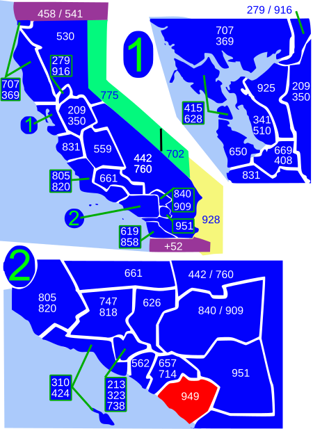
Area code 949

Area codes in CaliforniaArea codes in the United StatesOrange County, CaliforniaSan Diego County, California
Area code 949
Area code 949

Area code 949 is an area code in California that is contained within South Orange County California. On April 18, 1998, the southern cities of Orange County were split from 714, creating area code 949. It includes some of the wealthiest communities in California; including such cities as Newport Beach, Irvine, Lake Forest, Portola Hills, Coto de Caza, Dove Canyon, Aliso Viejo, Trabuco Canyon, Capistrano Beach, Corona Del Mar, Laguna Niguel, Laguna Hills, Laguna Woods, Newport Coast, Foothill Ranch, Robinson Ranch, Mission Viejo, San Juan Capistrano, Rancho Santa Margarita, Ladera Ranch, Dana Point, Laguna Beach, and San Clemente. The city of Costa Mesa is shared between the 949 and 714 area codes, being split at Wilson Street and along Newport Boulevard. A very small portion of Irvine is also in the 714 area code, from the north side of Culver Drive at the I-5 to Jamboree Road in the Marketplace, in the neighborhood of Northpark Irvine.

Excerpt from the Wikipedia article Area code 949 (License: CC BY-SA 3.0, Authors, Images).

Area code 949
Sunset Place East,

Geographical coordinates (GPS) Address Nearby Places
placeShow on map

Wikipedia: Area code 949Continue reading on Wikipedia

Geographical coordinates (GPS)

Latitude Longitude
N 33.6 ° E -117.7 °
placeShow on map

Address

Sunset Place East 24965
92653 , Acacia Knolls
California, United States
mapOpen on Google Maps

Area code 949
Area code 949
Share experience

Nearby Places

Monterey Formation
Monterey Formation

The Monterey Formation is an extensive Miocene oil-rich geological sedimentary formation in California, with outcrops of the formation in parts of the California Coast Ranges, Peninsular Ranges, and on some of California's off-shore islands. The type locality is near the city of Monterey, California. The Monterey Formation is the major source-rock for 37 to 38 billion barrels of oil in conventional traps such as sandstones. This is most of California's known oil resources. The Monterey has been extensively investigated and mapped for petroleum potential, and is of major importance for understanding the complex geological history of California. Its rocks are mostly highly siliceous strata that vary greatly in composition, stratigraphy, and tectono-stratigraphic history. The US Energy Information Administration (EIA) estimated in 2014 that the 1,750 square mile Monterey Formation could, as an unconventional resource, yield about 600 million barrels of oil, from tight oil contained in the formation, down sharply from their 2011 estimate of a potential 15.4 billion barrels. An independent review by the California Council on Science and Technology found both of these estimates to be "highly uncertain." Despite intense industry efforts, there has been little success to date (2013) in producing Monterey-hosted tight oil/shale oil, except in places where it is already naturally fractured, and it may be many years, if ever, before the Monterey becomes a significant producer of shale oil. The Monterey Formation strata vary. Its lower Miocene members show indications of weak coastal upwelling, with fossil assemblages and calcareous-siliceous rocks formed from diatoms and coccolithophorids. Its middle and upper Miocene upwelling-rich assemblages, and its unique highly siliceous rocks from diatom-rich plankton, became diatomites, porcelainites, and banded cherts.