place

London Road (Brighton) railway station

David Mocatta railway stationsFormer London, Brighton and South Coast Railway stationsRailway stations in Brighton and HoveRailway stations in Great Britain opened in 1877Railway stations served by Southern
Use British English from March 2017
London Road (Brighton)

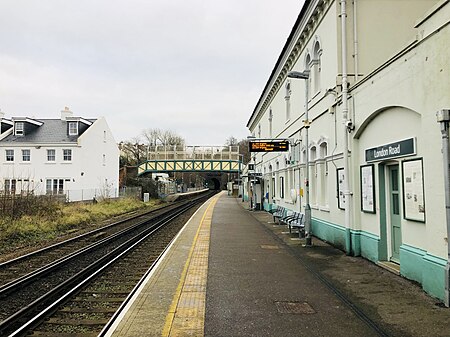
London Road (Brighton) railway station is a railway station located in Round Hill, an eastern suburb of Brighton in East Sussex. It is the first intermediate station on the Brighton branch of the East Coastway Line, 57 chains (1.1 km) down the line from Brighton station. The station is managed by Southern, who operate all services on the line. Despite its name, the station is not located on London Road, which passes some 400 yards (370 m) southwest of the station and bears the name Preston Road at the nearest point.

Excerpt from the Wikipedia article London Road (Brighton) railway station (License: CC BY-SA 3.0, Authors, Images).

London Road (Brighton) railway station
Shaftesbury Place, Brighton Round Hill

Geographical coordinates (GPS) Address Nearby Places
placeShow on map

Wikipedia: London Road (Brighton) railway stationContinue reading on Wikipedia

Geographical coordinates (GPS)

Latitude Longitude
N 50.836666666667 ° E -0.13638888888889 °
placeShow on map

Address

London Road

Shaftesbury Place
BN1 4QQ Brighton, Round Hill
England, United Kingdom
mapOpen on Google Maps

London Road (Brighton)
Share experience

Nearby Places

New England Quarter
New England Quarter

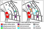
The New England Quarter is a mixed-use development in the city of Brighton and Hove, England. It was built between 2004 and 2008 on the largest brownfield site in the city, adjacent to Brighton railway station. Most parts of the scheme have been finished, but other sections are still being built and one major aspect of the original plan was refused planning permission.The site, a steeply sloping hillside between a main railway line and one of Brighton's main roads, had been the home of a railway locomotive works and goods yard for more than a century. High-density housing was built at the same time and surrounded the railway buildings. From the 1960s, the area fell into decline: the works and goods yard were closed and demolished, and most of the housing was cleared. This left large areas of derelict land which attracted small-scale redevelopment and transient commercial enterprises. Proposals for redevelopment were made from the 1980s onwards; in 2001 a master plan was granted planning permission by Brighton and Hove City Council. Site clearance work followed, and construction began in 2004. The New England Quarter consists of separately planned areas (called "Blocks" in the master plan) connected by new or altered road infrastructure and pedestrian links. Land use includes private and council housing of various styles and configurations, office and retail space, a college, a hotel, public space and community facilities. Some of the residential development aims to meet high environmental and sustainability standards, and green space is being provided on former railway land. The scheme has attracted criticism from various sources, and certain aspects and proposals have been particularly controversial. A planned 42-storey hotel and residential building on one block—which was not in the original plan and for which planning permission was later denied—was opposed by many local people and politicians, and was eventually rejected by a government minister on appeal. The decision to allow a large supermarket branch to be built in the middle of the development was also unpopular. A campaign group was formed to co-ordinate and raise the awareness of people's concerns.

Round Hill, Brighton

Round Hill (sometimes spelt Roundhill) is an inner suburban area of Brighton, part of the coastal city of Brighton and Hove in England. The area contains a mix of privately owned and privately rented terraced housing, much of which has been converted for multiple occupancies, and small-scale commercial development. It was developed mostly in the late 19th century on an area of high land overlooking central Brighton and with good views in all directions, the area became a desirable middle-class suburb—particularly the large terraced houses of Roundhill Crescent and Richmond Road, and the exclusive Park Crescent—and within a few decades the whole of the hill had been built up with smaller terraces and some large villas. Non-residential buildings include the landmark St Martin's Church, Brighton's largest place of worship, with its dramatically extravagant interior; the Brighton Forum, a Gothic Revival former college now in commercial use; Brighton's main fire station; and the oldest working cinema in Britain. The first hospital in England catering for mental illness was established in a house in Roundhill Crescent in 1905. Brighton's first Jewish cemetery, although a short distance outside Round Hill according to Brighton & Hove City Council's definition, has been associated with the suburb throughout its near 200-year history. The London Road viaduct, a distinctive, sweeping piece of railway architecture, forms the northern boundary of the area and "a literal gateway" between outer and inner suburbia. All of these buildings have been listed by English Heritage for their architectural and historical importance, and the core of Round Hill, around Roundhill Crescent, is one of 34 conservation areas in the city. Round Hill's steep slopes and road layout encouraged the introduction of another feature which gives the area its character: the "cat's-creep" staircase. The area has good tree cover and increasingly heavy traffic along the three main roads which run through the area. Past features of Round Hill include a windmill, which took advantage of the windy conditions on the 223-foot (68 m) hilltop until 1913; 19th-century laundries, which sought the same advantage; early 19th-century pleasure gardens, now occupied by the houses of Park Crescent; the landmark Cox's Pill Factory, demolished in the 1980s; glasshouses and smallholdings, some of which survived until after the Second World War despite being surrounded by houses; and the Kemp Town branch line, a passenger and freight railway which cut through the area and had a short-lived station serving Round Hill. The former St Saviour's Church survived until 1983, and a Congregational church elsewhere in the suburb closed but retained its façade after its conversion into housing.