Gamston, Bassetlaw

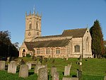
Gamston is a village and civil parish four miles south of Retford in the English county of Nottinghamshire. The village lies on the A638 road between Retford and the Markham Moor junction with the A1 and the A57 roads. The population of the civil parish as at the 2011 Census was 246. The River Idle lies to the west of the village. St Peter's Church is a Grade I listed building. Gamston was home to a rectory in the past, and today forms the name of a lane in the village.To the east of the village, beyond the East Coast railway line, is Gamston Wood. The ancient parish wood was purchased by the Forestry Commission in 1984 and covers 41 hectares (100 acres). The area has been designated as a Site of Specific Interest.
Excerpt from the Wikipedia article Gamston, Bassetlaw (License: CC BY-SA 3.0, Authors, Images).Gamston, Bassetlaw
Muttonshire Hill, Bassetlaw Gamston
Geographical coordinates (GPS) Address Nearby Places Show on map
Geographical coordinates (GPS)
| Latitude | Longitude |
|---|---|
| N 53.28 ° | E -0.94 ° |
Address
Muttonshire Hill
Muttonshire Hill
DN22 0QH Bassetlaw, Gamston
England, United Kingdom
Open on Google Maps


