place

Mount Pearl South

Mount PearlNewfoundland and Labrador provincial electoral districts
Mount Pearl South
Mount Pearl South

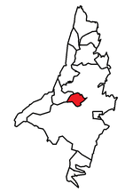
Mount Pearl South is a defunct provincial electoral district for the House of Assembly of Newfoundland and Labrador, Canada. Prior to the 2007 provincial election, the district was known as Mount Pearl. Mount Pearl South has seen an expansion in big-box retail outlets in recent years. In 2011, there were 8,114 eligible voters living within the district.The district was created in 1975 and was a Tory stronghold for two decades, with Progressive Conservative Neil Windsor holding the seat from 1975 to 1995. The seat went Liberal in 1996 when Brian Tobin won a large majority government, but returned to the Progressive Conservatives, under Dave Denine, in 2003 when the party swept back to power. Denine won again in the 2007 election. Dave Denine retired just before the writ was dropped in 2011. The 2011 Election was contested between Progressive Conservative nominee Paul Lane, a Mount Pearl city councillor, New Democrat John Riche, a Real Estate Agent and Liberal Norm Snelgrove, a civic administrator. Paul Lane won the 2011 contest by 700 votes on October 11, 2011 and remained the district's MHA until its dissolution. On January 20, 2014 Paul Lane announced he was leaving the governing PC Party to sit with the Opposition Liberal Party. In 2015, an electoral district boundary review resulted in the districts dissolution, with its territory being incorporated into Mount Pearl-Southlands.

Excerpt from the Wikipedia article Mount Pearl South (License: CC BY-SA 3.0, Authors, Images).

Mount Pearl South
Bettney Place, Mount Pearl

Geographical coordinates (GPS) Address Nearby Places
placeShow on map

Wikipedia: Mount Pearl SouthContinue reading on Wikipedia

Geographical coordinates (GPS)

Latitude Longitude
N 47.501 ° E -52.807 °
placeShow on map

Address

Bettney Place

Bettney Place
A1N 4Y9 Mount Pearl
Newfoundland and Labrador, Canada
mapOpen on Google Maps

Mount Pearl South
Mount Pearl South
Share experience

Nearby Places

St. John's, Newfoundland and Labrador

St. John's is the capital and largest city of the Canadian province of Newfoundland and Labrador. It is located on the eastern tip of the Avalon Peninsula on the island of Newfoundland. The city spans 446.04 km2 (172.22 sq mi) and is the easternmost city in North America (excluding Greenland).Its name has been attributed to the belief that John Cabot sailed into the harbour on the Nativity of John the Baptist in 1497, although it is most likely a legend that came with British settlement. A more realistic possibility is that a fishing village with the same name existed without a permanent settlement for most of the 16th century. Indicated as São João on a Portuguese map from 1519, it is one of the oldest cities in North America. It was officially incorporated as a city in 1888. With a metropolitan population of approximately 212,579 (as of 9 February 2022), the St. John's Metropolitan Area is Canada's 20th-largest metropolitan area and the second-largest Census Metropolitan Area (CMA) in Atlantic Canada, after Halifax.The city has a rich history, having played a role in the Seven Years' War, the American Revolutionary War, and the War of 1812. Italian inventor Guglielmo Marconi received the first transatlantic wireless signal in St. John's. Its history and culture have made it into an important tourist destination. St. John's was referred to as Baile Sheáin (Johnstown), in the poetry of Donnchadh Ruadh Mac Conmara (1715–1810), and among speakers of the Irish language in Newfoundland.

Kenmount Road

Kenmount Road is a major road in St. John's, Newfoundland and Labrador. It begins at the intersection of Freshwater Road and Thorburn Road, just east of the Columbus Drive overpass. Originally passing through rural farmland, Kenmount Road is now a significant commercial area, with the Avalon Mall at its eastern end, followed by a series of car dealerships, restaurants, hotels, and other businesses. At its western end, Kenmount Road intersects Topsail Road and the Trans-Canada Highway, and has been extended into the Town of Paradise, where it runs into another road, McNamara Drive. O'Leary Industrial Park is located just north of Kenmount Road, with access via Pippy Place and Peet Street. Further west, past the intersection with the Team Gushue Highway, lies the Kelsey Drive big-box retail area. West of Kelsey Drive, the new Kenmount Terrace subdivision is currently under development. In the 2022 provincial budget it was announced that a school would be constructed in Kenmount Terrace, a first for the area.The Trans-Canada Highway originally continued down Kenmount Road, prior to the construction of the Outer Ring Road in the 1990s, which diverted the highway onto a new alignment across the north of the city. The overpass that carries Kenmount Road (originally the Trans-Canada Highway) over Topsail Road holds a special place in the province. One of the first highway interchanges constructed in the province, it has come to represent the boundary between the St. John's urban region and the remainder of the island. The phrase "beyond the overpass" is commonly used to refer collectively to all areas of Newfoundland that lie outside the boundaries of metro St. John's.