place

Rauceby Hospital

Defunct hospitals in EnglandFormer psychiatric hospitals in EnglandHospital buildings completed in 1902Hospitals in LincolnshireMilitary hospitals in the United Kingdom
Municipal hospitalsSleaford
Greylees park & Rauceby Hospital geograph.org.uk 4413351

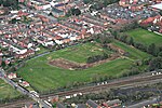
Rauceby Hospital, originally called Kesteven County Asylum, is a now-defunct mental institution in the parish of Quarrington, Lincolnshire, England. Originally opened in 1902, the main hospital building was closed in 1997 and the site has since been redeveloped.

Excerpt from the Wikipedia article Rauceby Hospital (License: CC BY-SA 3.0, Authors, Images).

Rauceby Hospital
North Kesteven

Geographical coordinates (GPS) Address Nearby Places
placeShow on map

Wikipedia: Rauceby HospitalContinue reading on Wikipedia

Geographical coordinates (GPS)

Latitude Longitude
N 52.9839 ° E -0.4509 °
placeShow on map

Address


NG34 8ZW North Kesteven
England, United Kingdom
mapOpen on Google Maps

Greylees park & Rauceby Hospital geograph.org.uk 4413351
Share experience

Nearby Places

Quarrington, Lincolnshire

Quarrington is a village and former civil parish, now part of the civil parish of Sleaford, in the North Kesteven district of Lincolnshire, England. The old village and its church lie approximately 1 miles (2 km) south-west from the centre of Sleaford. Suburban housing developments at New Quarrington and Quarrington Hill effectively link the two settlements. Bypassed by the A15, it is connected to Lincoln and Peterborough, as well as Newark and King's Lynn (via the A17). At the 2011 census, Quarrington and Mareham ward, which incorporates most of the settlement, had an estimated population of 7,046. Quarrington was a rural community during the early and middle Anglo-Saxon period while mills along the River Slea in the Middle Ages gave the village its likely alternative name of Millthorpe. The Bishop of Lincoln and Ramsey Abbey held manors in Quarrington after the Norman Conquest, but the Carre family of Sleaford were the principal land-owners between 1559 and 1683, when its estate passed by marriage to the Marquesses of Bristol. Although the growth of Victorian Sleaford saw the town encroach into the parish's boundaries, the old village remained a small cluster of farm buildings and cottages for much of its history. The sale of most of the surrounding farmland by successive Marquesses of Bristol in the late 20th century led to the rapid development of residential estates on Quarrington Hill and in New Quarrington which have engulfed the original settlement. Low crime rates, affordable housing, high standards of living and access to good schools have attracted home-buyers to the area, contributing to a sharp rise in the population. The medieval St Botolph's Church, a grade II* listed building, lies at the heart of the old village and remains a hub for the Anglican community. The village's primary school serves local children, who continue their secondary education in one of Sleaford's three secondary schools. The nearest railway station on the Grantham to Skegness and Peterborough to Lincoln lines is in Sleaford. In the 19th century, the most common employment was in agriculture and more than half of the village's population were farm labourers. By 2011, most residents were employed in the wholesale and retail trades, public administration and defence, human health and social work, and manufacturing.

Sleaford
Sleaford

Sleaford is a market town and civil parish in the North Kesteven district of Lincolnshire, England. Centred on the former parish of New Sleaford, the modern boundaries and urban area include Quarrington to the south-west, Holdingham to the north and Old Sleaford to the east. The town is on the edge of the fertile Fenlands, 11 miles (18 kilometres) north-east of Grantham, 16 mi (26 km) west of Boston, and 17 mi (27 km) south of Lincoln. Its population of 17,671 at the 2011 Census made it the largest settlement in the North Kesteven district; it is the district's administrative centre. Bypassed by the A17 and the A15, it is linked to Lincoln, Newark, Peterborough, Grantham and King's Lynn. The first settlement formed in the Iron Age where a prehistoric track crossed the River Slea. It was a tribal centre and home to a mint for the Corieltauvi in the 1st centuries BC and AD. Evidence of Roman and Anglo-Saxon settlement has been found. During the period of Danelaw, the area was actively populated. There are not only many names of places in the area that end in -by or -thorpe, but also the -gate ending of streets in Sleaford itself (North Gate, Eastgate, Westgate, South Gate and Watergate). All these bear witness to a population with a profoundly Scandinavian origin. The medieval records differentiate between Old and New Sleaford, the latter emerging by the 12th century around the present-day market place and St Denys' Church; Sleaford Castle was also built at that time for the Bishops of Lincoln, who owned the manor. Granted the right to hold a market in the mid-12th century, New Sleaford developed into a market town and became locally important in the wool trade, while Old Sleaford declined. From the 16th century, the landowning Carre family kept tight control over the town – it grew little in the early modern period. The manor passed from the Carre family to the Hervey family by the marriage of Isabella Carre to John Hervey, 1st Earl of Bristol in 1688. The town's common land and fields were legally enclosed by 1794, giving ownership mostly to the Hervey family. This coincided with canalisation of the Slea. The Sleaford Navigation brought economic growth until it was superseded by the railways in the mid-1850s. In the 20th century, the sale of farmland around Sleaford led to the development of large housing estates. Sleaford was mainly an agricultural town until the 20th century with a cattle market. Seed companies such as Hubbard and Phillips and Sharpes International were established in the late 19th century. The arrival of the railway made the town favourable for malting, but the industry has since declined. In 2011, the commonest occupations were in wholesale and retail trading, health and social care, public administration, defence and manufacturing. Regeneration of the town centre has helped to regenerate the earlier industrial areas, including construction of the National Centre for Craft & Design (The Hub) on an old wharf.

St George's Academy

St George's Academy is a co-educational comprehensive secondary school based in the English market town of Sleaford in Lincolnshire, with a satellite school at nearby Ruskington. Its origins date to 1908, when Sleaford Council School opened at Church Lane to meet the growing demand for elementary education in the town. After the Education Act 1944, the senior department became a secondary modern. A second school building was constructed at Westholme in the 1950s and expanded in 1983, allowing the Church Lane site to close; to mark the occasion, it was renamed St George's School. After it became grant-maintained, the school became a comprehensive, received a Technology specialism, became a Technology College in 1994 and later converted to Foundation status. Throughout the 1990s and 2000s, new buildings were added to the site. Coteland's School in Ruskington federated with St George's in 2007; they merged to form the Academy in 2010. The conversion included a government grant of £20 million to carry out extensive building work on both sites, completed in 2012 at Sleaford and in 2015 at Ruskington. The Sleaford school opened with a capacity for 600 pupils in 1908, but St George's had over 2,230 on roll across both sites in 2021, including the Sixth Form; the Ruskington site, with roughly 350 pupils, makes up a small proportion of the total. Pupils generally sit examinations for General Certificate of Secondary Education (GCSE) or equivalent vocational qualifications in Year Eleven (aged 15–16), and they have a choice of three or four A-levels or vocational options in the sixth form, which is part of the Sleaford Joint Sixth Form consortium with the town's single-sex grammar schools. In 2019, the school received an "average" Progress 8 score; 31% of pupils achieved English and mathematics GCSEs at grade 5 or above, which was lower than the national figure. The average A-Level grade in 2019 was a C, slightly below the national figure; the government's progress score for the Sixth Form is "well below average". An Office for Standards in Education, Children's Services and Skills (Ofsted) inspection in 2015 graded St George's Academy as "good" in every category. This rating was confirmed following a short inspection in 2019.