To Kwa Wan

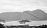
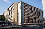
To Kwa Wan (traditional Chinese: 土瓜灣; simplified Chinese: 土瓜湾; Jyutping: tou2 gwaa1 waan1; pinyin: Tǔguāwān) is a bay and an area of the eastern shore of Kowloon peninsula. The area is part of urban Hong Kong, and is situated between Hok Yuen, Hung Hom, Ma Tau Wai and Ma Tau Kok. Administratively, the area belongs to the Kowloon City District of Kowloon. To Kwa Wan is a mixed residential and commercial area, located to the west of the old Kai Tak Airport. It comprises mostly mid-20th century residential and light industrial architecture of 10 or fewer floors, built to comply with height restrictions for the former Kai Tak Airport. Since the airport closed in 1998, new buildings are taller, often with commercial space on the ground floor, especially along major roads such a Ma Tau Wai Road. Consequently, the area has a much-valued cohesive community spirit.To Kwa Wan station services this area.
Excerpt from the Wikipedia article To Kwa Wan (License: CC BY-SA 3.0, Authors, Images).To Kwa Wan
Ha Heung Road, Kowloon To Kwa Wan (Kowloon City District)
Geographical coordinates (GPS) Address Nearby Places Show on map
 Continue reading on Wikipedia
 Geographical coordinates (GPS)
| Latitude | Longitude |
|---|---|
| N 22.31885 ° | E 114.1907 ° |
Address
土瓜灣體育館 To Kwa Wan Sports Centre
Ha Heung Road
Kowloon, To Kwa Wan (Kowloon City District)
Hong Kong, China
Open on Google Maps