place

Hindlow railway station

Disused railway stations in DerbyshireFormer London and North Western Railway stationsPages with no open date in Infobox stationPeak DistrictRailway stations in Great Britain closed in 1954
Railway stations in Great Britain opened in 1856Use British English from January 2018
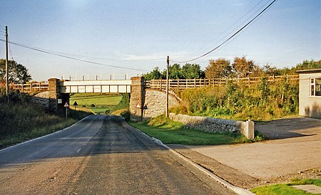
Hindlow station site geograph 3678454 by Ben Brooksbank

Hindlow railway station was opened for goods in 1833 near to Hindlow near King Sterndale to the south east of Buxton, Derbyshire on the Cromford and High Peak Railway (which ran from Whaley Bridge to Cromford) and the LNWR line to Ashbourne and the south.

Excerpt from the Wikipedia article Hindlow railway station (License: CC BY-SA 3.0, Authors, Images).

Hindlow railway station
Brierlow lane, High Peak Hartington Upper Quarter

Geographical coordinates (GPS) Address External links Nearby Places
placeShow on map

Wikipedia: Hindlow railway stationContinue reading on Wikipedia

Geographical coordinates (GPS)

Latitude Longitude
N 53.2203 ° E -1.8729 °
placeShow on map

Address

Hindlow

Brierlow lane
SK17 9PX High Peak, Hartington Upper Quarter
England, United Kingdom
mapOpen on Google Maps

linkWikiData (Q5766118)
linkOpenStreetMap (8289562778)

Hindlow station site geograph 3678454 by Ben Brooksbank
Share experience

Nearby Places

Deep Dale
Deep Dale

Deep Dale is a short steep-sided gorge near Buxton, Derbyshire, in the Peak District of England. It is distinct from another Deep Dale, near Sheldon, 4 miles (6.4 km) to the east. The dale is cut into a plateau of farmland and lies just south west of the hamlet of King Sterndale. The head of the valley is called Back Dale and there is a side valley called Horseshoe Dale. Wye Dale is at the foot of the valley to the north. The valley is dry over the summer but has a winterbourne stream, fed by the Deepdale Side Resurgence spring and another spring by Thirst House Cave further up the valley. The stream runs into the River Wye. Thirst House Cave's name is derived from Th'Hurst House as it was earlier called Hob Hurst House, named after a goblin believed to live in the cave (not to be confused with Hob Hurst's House prehistoric burial mound on Beeley Moor). The cave is 58 metres (190 ft) long. Local men Micah Salt and Robert Milletts excavated the cave in the 1880s and 1890s, after boys found a bear's skull in the cave. They discovered Roman artefacts, including bronze jewellery, enamelled brooches, pottery fragments, coins and an iron and bone knife. Many of these objects are on display in the Buxton Museum.Deep Dale and Topley Pike is a protected nature reserve, which is overseen by the Derbyshire Wildlife Trust. The reserve contains whitebeam, yew, ash and hazel trees and limestone fern on the lower scree slopes, with bilberry, cowberry and wild flowers on the steep upper slopes, including bloody crane's bill, clustered bellflower, rock rose and Nottingham catchfly. Without sheep grazing, the native grasses of meadow oat and carnation sedge flourish. The limestone cliffs are an attractive habitat for kestrels and jackdaws. Topley Pike and Deep Dale is also a designated Site of Special Scientific Interest (SSSI).The Buxton to Chelmorton section of the Midshires Way long-distance footpath runs across Deep Dale. The Priest's Way path runs through the valley floor of Deep Dale and Horseshoe Dale. The Peak District Boundary Walk route comes down Deep Dale and along Wye Dale before heading north at Chee Dale. The crags of carboniferous limestone in Deep Dale are popular with rock climbers. There are four buttresses along the valley with many climbing routes.Topley Pike Quarry is a large limestone quarry at the north west end of Deep Dale. It was opened in 1907 by Messrs. Newton Chambers & Co. and is currently operated by Tarmac Roadstone Holdings Ltd. A drystone wall runs along the length of the floor of the dale and marks the boundary between the mining rights of Buxton Mining Liberty and the Combined Liberty of Taddington, Flagg, Monyash and Upper Haddon.Access into the deep gorge is limited. Wye Dale car park (over the A6 road at the north end of Deep Dale) is the easiest place for visitors to walk from. There are four other entry points over stiles into the dale and its nature reserve from neighbouring dales (Chelmorton, King Sterndale, Horseshoe Dale and Brierlow Dale), although these have steep slopes. The footpath through the lower section of Deep Dale is closed from 2017 until 2025 for natural restoration, following the removal of a large spoil tip (waste from the quarry). A diversion is in place to the east.
Chrome Hill
Chrome Hill

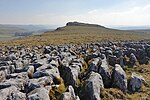
Chrome Hill is a limestone reef knoll in Derbyshire, England, in the upper Dove valley beside the border with Staffordshire, within the civil parish of Hartington Middle Quarter. It is adjacent to Parkhouse Hill, another reef knoll. The walk over Chrome Hill and Parkhouse Hill is known as the Dragon's Back ridge.Chrome Hill was declared open access land under the provisions of the Countryside and Rights of Way Act 2000. However, the only access from the north west remains along a concessionary footpath. Chrome Hill contains good exposures of Gigantoproductus fossils; it is part of a designated Site of Special Scientific Interest which makes it an offence for visitors to remove geological samples. A double sunset can sometimes be seen against Chrome Hill from the southern flank of Parkhouse Hill; and also from nearby Glutton Bridge, on the upper valley of the River Dove, which is more easily accessible. The phenomenon is visible from Glutton Bridge in good weather for a short period around the summer solstice, when the sun sets just to the southwest of the summit of Chrome Hill, begins to re-emerge almost immediately afterwards from its steep northeastern slope before fully reappearing and later sets for a second and final time at the foot of the hill.Chrome Hill has had songs written in its honour by the Norwegian musicians Sigurd Hole (Chrome Hill) and Jonas Howden Sjøvaag (Up on Chrome Hill). In 2008 the Norwegian jazz quartet Damp changed its name to Chrome Hill. Broadcast in 2022, the final episode of the final season of Peaky Blinders was filmed overlooking Chrome Hill.

Harpur Hill
Harpur Hill

Harpur Hill is a small village on the outskirts of Buxton, Derbyshire, England. It is in the Cote Heath ward of the High Peak Borough Council. It has a primary school, a park, a pub, a working men's club and a Methodist church. From 1938 to 1969, the RAF Maintenance Unit 28 was based at Harpur Hill and it included the RAF Mountain Rescue Team for the Peak District. RAF Harpur Hill was established as an underground munitions store. Tunnels were dug out to house munitions and ordnance. When the RAF left the tunnels were used as a mushroom farm. When the tunnels closed they were sold to a group of local businessmen and used as a cold store for cheese; a warehouse was built for dry and bonded wines and spirits. A number of local hauliers provided the transport for these goods. One of the hauliers was Lomas Distribution which was bought out by Christian Salvesen and was a major employer in the area; it later sold the site to French transport company Norbert Dentressangle. Many of the bunkers can still be seen in the surrounding hillside.The Health and Safety Executive Laboratory is not far from Harpur Hill. From 1916 to 1918 the site housed The Frith Artillery Range. A railway was constructed with old London Underground Jubilee Line trains which were used to reconstruct the 7 July 2005 London bombings. A red flag is flown at the laboratory when an explosion is imminent.Also nearby is Far Hill Quarry, now flooded, where swimming is discouraged by the authorities as unsafe due to the high pH level of the water.Harpur Hill is the base of Harpur Club & Harpur Hill FC, and of Buxton Rugby Union Club. The tops of the rugby club's goal posts are the highest in the country.