place

High Edge

BuxtonMountains and hills of DerbyshireMountains and hills of the Peak DistrictUse British English from March 2020
High Edge, Buxton, Derbyshire

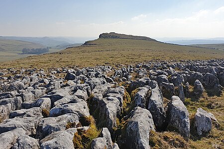
High Edge is a limestone hill overlooking Harpur Hill, Buxton in Derbyshire, in the Peak District. The summit is 472 metres (1,549 ft) above sea level. The lower hilltop (about 400m north-west of the summit) is marked by a cairn.Following the Countryside and Rights of Way Act 2000, this hilltop area became "Open Access" land for the public.There are two machine gun bunkers on the hilltop as part of the defences of the former RAF Harpur Hill. From 1938 to 1969, the RAF Maintenance Unit 28 was based at Harpur Hill. The RAF site was established as an underground ammunitions store with an extensive tunnel system to house munitions and ordnance. The site is now operated by the Health and Safety Executive Laboratory, which has had a presence on the site since 1947, when it was the Safety in Mines Research Establishment (SMRE). On the north-west side of High Edge is Buxton Raceway, a modern oval motorsport track. Racing started at the site in 1974 when it was known as 'High Edge'.

Excerpt from the Wikipedia article High Edge (License: CC BY-SA 3.0, Authors, Images).

High Edge
Washgate Lane, High Peak Hartington Upper Quarter

Geographical coordinates (GPS) Address Nearby Places
placeShow on map

Wikipedia: High EdgeContinue reading on Wikipedia

Geographical coordinates (GPS)

Latitude Longitude
N 53.21605 ° E -1.90717 °
placeShow on map

Address

Washgate Lane
SK17 0RP High Peak, Hartington Upper Quarter
England, United Kingdom
mapOpen on Google Maps

High Edge, Buxton, Derbyshire
Share experience

Nearby Places

Chrome Hill
Chrome Hill

Chrome Hill is a limestone reef knoll in Derbyshire, England, in the upper Dove valley beside the border with Staffordshire, within the civil parish of Hartington Middle Quarter. It is adjacent to Parkhouse Hill, another reef knoll. The walk over Chrome Hill and Parkhouse Hill is known as the Dragon's Back ridge.Chrome Hill was declared open access land under the provisions of the Countryside and Rights of Way Act 2000. However, the only access from the north west remains along a concessionary footpath. Chrome Hill contains good exposures of Gigantoproductus fossils; it is part of a designated Site of Special Scientific Interest which makes it an offence for visitors to remove geological samples. A double sunset can sometimes be seen against Chrome Hill from the southern flank of Parkhouse Hill; and also from nearby Glutton Bridge, on the upper valley of the River Dove, which is more easily accessible. The phenomenon is visible from Glutton Bridge in good weather for a short period around the summer solstice, when the sun sets just to the southwest of the summit of Chrome Hill, begins to re-emerge almost immediately afterwards from its steep northeastern slope before fully reappearing and later sets for a second and final time at the foot of the hill.Chrome Hill has had songs written in its honour by the Norwegian musicians Sigurd Hole (Chrome Hill) and Jonas Howden Sjøvaag (Up on Chrome Hill). In 2008 the Norwegian jazz quartet Damp changed its name to Chrome Hill. Broadcast in 2022, the final episode of the final season of Peaky Blinders was filmed overlooking Chrome Hill.

Harpur Hill
Harpur Hill

Harpur Hill is a small village on the outskirts of Buxton, Derbyshire, England. It is in the Cote Heath ward of the High Peak Borough Council. It has a primary school, a park, a pub, a working men's club and a Methodist church. From 1938 to 1969, the RAF Maintenance Unit 28 was based at Harpur Hill and it included the RAF Mountain Rescue Team for the Peak District. RAF Harpur Hill was established as an underground munitions store. Tunnels were dug out to house munitions and ordnance. When the RAF left the tunnels were used as a mushroom farm. When the tunnels closed they were sold to a group of local businessmen and used as a cold store for cheese; a warehouse was built for dry and bonded wines and spirits. A number of local hauliers provided the transport for these goods. One of the hauliers was Lomas Distribution which was bought out by Christian Salvesen and was a major employer in the area; it later sold the site to French transport company Norbert Dentressangle. Many of the bunkers can still be seen in the surrounding hillside.The Health and Safety Executive Laboratory is not far from Harpur Hill. From 1916 to 1918 the site housed The Frith Artillery Range. A railway was constructed with old London Underground Jubilee Line trains which were used to reconstruct the 7 July 2005 London bombings. A red flag is flown at the laboratory when an explosion is imminent.Also nearby is Far Hill Quarry, now flooded, where swimming is discouraged by the authorities as unsafe due to the high pH level of the water.Harpur Hill is the base of Harpur Club & Harpur Hill FC, and of Buxton Rugby Union Club. The tops of the rugby club's goal posts are the highest in the country.

Solomon's Temple, Buxton

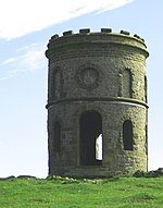
Solomon's Temple, also known as Grinlow Tower, is a Victorian folly on the summit of Grin Low hill, near the spa town of Buxton in the Derbyshire Peak District.On 23 February 1894, a meeting at Buxton Town Hall decided to rebuild a landmark tower that had been built by Solomon Mycock, of the Cheshire Cheese Hotel, in the early 19th century, and of which only a few stones remained. The Local Board vice-chairman had talked with the seventh Duke of Devonshire's agent and decided that the reconstruction was feasible if the townspeople would donate sufficient money. Sketches were submitted by architects W. R. Bryden and G. E. Garlick. By that May, the plans were confirmed by the Duke of Devonshire, and it was well known that the site was of prehistoric importance. In June 1894, the seventh Duke of Devonshire subscribed £25 towards building the folly. Buxton had already subscribed £50. The foundation stone was laid by Colonel Sidebottom, M.P., on 31 May 1896, witnessed by a large crowd, and the tower was opened by Victor Cavendish in September 1896. The tower was restored in 1988 by public subscription.The structure is a 20-foot-high (6.1 m), two-storey tower built on top of a Bronze Age barrow, sitting on top of a ridge at a height of 440 metres (1,440 ft) above sea level. From the open top of the tower there are good 360-degree views over the town and the surrounding countryside and parts of the Peak District. The tower does not contain anything other than the staircase to the top. It is a Grade II listed building.

Staden, Derbyshire
Staden, Derbyshire

Staden is a small hamlet (of just a few buildings) on the southern outskirts of Buxton, Derbyshire, lying between Harpur Hill and Cowdale. It was occupied in Neolithic, Roman and medieval times. Staden is close to the limestone hilltop of Staden Low whose summit is 367 m (1,204 ft) above sea level.Staden Low prehistoric earthwork is in a field on the western side of Staden Low hill. It is in the form of a slightly raised circular bank (over 50m across) with a smaller adjoining rectangular bank (which is a unique enclosure feature of British henges). Neolithic artefacts were discovered during excavations in 1926 by Mr R. Woolescroft, including a polished stone axe head and many fragments of knapped flint. Further excavations by Dr G. Makepeace in the 1980s uncovered Neolithic pottery sherds and pieces of deer antlers. The finds are on display in Buxton Museum. The site is a protected Scheduled Monument. Aerial LIDAR image of Staden Enclosure by the Environment Agency. Staden is one mile south of the Roman town of Aquae Arnemetiae (Roman Buxton) and there was a Roman farm at Staden (around the present Colt Croft Farm). The fields around Staden have rich volcanic soils for farming. Excavations by Dr Makepeace in the 1980s found the platforms of several buildings, walls, field enclosure banks, quern grinding stones, pottery, animal bones and jewellery. The potter's stamp of Sepuminus dates the pottery to 100–130 AD. A hypocaust tile found in the farm house demonstrates that it had an underfloor heating system. The stone platform of a 12th-century medieval longhouse (22m long) was also identified at the same site in 1989. Documents record Staden as a farming settlement in 1101 AD.There are the remains of an old quarry and lime kiln immediately south of the hilltop.In 1896 Buxton Cemetery on Ashbourne Road was consecrated on 12 acres of land on Staden Moor. The gothic-style cemetery building (with a central archway and a mortuary chapel on either side), the caretaker's house and the registrar's office were designed by the town surveyor Joseph Hague. The tombstone of the Buxton archaeologist Micah Salt from 1915 is a replica of the Anglo-Saxon cross in Eyam cemetery and it is a Grade II listed structure.The new Buxton fire station and rescue centre (opened in 2011) and Staden industrial estate are on the A515 road past the cemetery. Buxton Brewery was established in 2009 and is based on Staden Lane.The Midshires Way and the Peak District Boundary Walk long-distance footpaths run along the same west–east route through Staden.