place

Westbank, British Columbia

Designated places in British ColumbiaPopulated places on Okanagan LakeWest Kelowna
Westbank, British Columbia Location

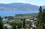
Westbank is one of the communities within the City of West Kelowna in the province of British Columbia. It is 12 km to the west of Kelowna. Other communities in West Kelowna include Casa Loma, West Kelowna Estates, Shannon Lake, Smith Creek, Glenrosa, Rose Valley and Lakeview Heights. Westbank sits to the south of West Kelowna. Westbank was for many years an unincorporated area within the Central Okanagan Regional District. In December 2007, following a governance referendum, it became a neighbourhood within what is now the City of West Kelowna. It has no legal borders since it is a neighbourhood and opinions vary as to exactly where Westbank begins and ends. As of January 2020, the City of West Kelowna has a total population of about 35,818.A post office was opened in 1902 and was named for its location on Okanagan Lake. The name was suggested by John Davidson who arrived in the district in 1892.: 292 Self-Government municipal regulatory powers have been given by treaty to the Westbank First Nation (WFN). Westbank First Nation spans 5,340 acres of Reservation land, separated into five land parcels.

Excerpt from the Wikipedia article Westbank, British Columbia (License: CC BY-SA 3.0, Authors, Images).

Westbank, British Columbia
Dobbin Road, West Kelowna Westbank

Geographical coordinates (GPS) Address Nearby Places
placeShow on map

Wikipedia: Westbank, British ColumbiaContinue reading on Wikipedia

Geographical coordinates (GPS)

Latitude Longitude
N 49.829166666667 ° E -119.62916666667 °
placeShow on map

Address

Dobbin Road
V4T 1E2 West Kelowna, Westbank
British Columbia, Canada
mapOpen on Google Maps

Westbank, British Columbia Location
Share experience

Nearby Places

Lakeview Heights, West Kelowna

Lakeview Heights is a community within the City of West Kelowna, British Columbia, Canada. Lakeview Heights is on the west side of Okanagan Lake, across the lake from Kelowna. Lakeview Heights is east of Mount Boucherie and south of Tsinstikeptum Indian Reserve No. 10. Residents representation is through the Lakeview Heights Community Association, a resident/member operated grassroots non-profit Special Interest Group. Member volunteers monitor and lobby government and are participants in local Public Advisory Councils and Committees. Many members volunteer their time and attend Community Open Houses, Government Information events, Community Issue Forums, and many participate and represent the LHCA on Public Advisory Committees. Lakeview Heights is home to orchards, riding stables, vineyards and wineries. Lakeview Heights has a standalone Lakeview Heights Community Hall, and a small shopping centre often referred to as the Anders Store due to its location. There are sports fields, tennis courts, parks and access to Okanagan Lake. Lakeview Heights is known for the panoramic views of surrounding areas and communities. Lakeview Heights with the many views of Okanagan Lake is often used by tourists to monitor and report on the travels of Ogopogo, a mythical inland sea monster. The Lakeview Irrigation District is the provider of local water needs. Lakeview Heights got its name from a winning contest entry from Geoff Gray in 1951..