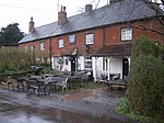
Steep, Hampshire

Steep is a village and civil parish in the East Hampshire district of Hampshire, England. Its nearest town is Petersfield, which lies 1.4 miles (2.3 km) south of the village, just off the A3 road. The nearest railway station is Petersfield, at 1.6 miles (2.6 km) south of the village. It has two public houses, The Harrow and the Cricketers Inn, with the former being an 18th-century Grade II listed building. According to the 2011 census, it had a population of 1,391. Iron Age and Roman remains have been found in the area. Steep formerly included two detached exclaves, the larger called Ambersham, which lay deep inside Sussex. These were two of the three detached portions of Hampshire in Sussex, and were annexed to that county when a new law came into effect in 1844. The church of All Saints was built around 1125. From medieval times, Steep was included in the parish of East Meon until it became an independent parish in 1867. Since 1899 the village has been the location of Bedales, a progressive public school.
Excerpt from the Wikipedia article Steep, Hampshire (License: CC BY-SA 3.0, Authors, Images).Steep, Hampshire
Church Road, East Hampshire Steep
Geographical coordinates (GPS) Address Nearby Places Show on map
Geographical coordinates (GPS)
| Latitude | Longitude |
|---|---|
| N 51.023 ° | E -0.945 ° |
Address
Church Road
Church Road
GU32 2DE East Hampshire, Steep
England, United Kingdom
Open on Google Maps


