South Bersted
Arun DistrictCommons link is defined as the pagenamePopulated coastal places in West SussexVillages in West SussexWest Sussex geography stubs

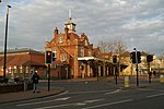
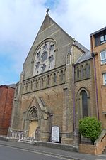
South Bersted is a village and parish in the Arun district of West Sussex, England. It forms part of the built up area of Bognor Regis and lies on the A259 and A29 roads one mile (1.6 km) north of the town centre. The Anglican parish church of Saint Mary Magdalene is mainly 13th century including the tower. Beginning as a chapel of Pagham it was a separate parish including Bognor by 1465.South Bersted C of E primary school has gained bronze and silver awards as an Eco-school.
Excerpt from the Wikipedia article South Bersted (License: CC BY-SA 3.0, Authors, Images).South Bersted
Bersted Street, Arun
Geographical coordinates (GPS) Address Nearby Places Show on map
Geographical coordinates (GPS)
| Latitude | Longitude |
|---|---|
| N 50.79403 ° | E -0.67517 ° |
Address
South Bersted Church
Bersted Street
PO22 9QB Arun
England, United Kingdom
Open on Google Maps


