place

Wythenshawe Hall

2010s fires in the United Kingdom2016 disasters in the United Kingdom2016 fires in EuropeBuildings and structures completed in 1540Country houses in Greater Manchester
Grade II* listed buildings in ManchesterGrade II* listed housesHistoric house museums in Greater ManchesterHouses in ManchesterMuseums in ManchesterSimon of Wythenshawe familyStructures on the Heritage at Risk registerTudor architectureUse British English from August 2015Wythenshawe
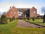
Wyhtenshawe Hall in 2005

Wythenshawe Hall is a 16th-century timber-framed historic house and former manor house in Wythenshawe, Manchester, England, five miles (8 km) south of Manchester city centre in Wythenshawe Park. Built for Robert Tatton, it was home to the Tatton family for almost 400 years. Its basic plan is a central hall with two projecting wings. In the winter of 1643–44 the house was besieged by Parliamentarian forces during the English Civil War. Despite the stout defence put up by Robert Tatton and his fellow Royalists, the defenders were overwhelmed by the Roundheads' superior weaponry. Rebuilding work was carried out at the end of the 18th century, and various additions made in the 19th century, including a walled garden, an ice house, glass houses and a tenant's hall. Wythenshawe Hall and its surrounding parkland were donated to Manchester Corporation in 1926, and in 1930 it was opened to the public as a museum. The building was badly damaged in an arson attack in March 2016; the hall finally reopened to visitors in September 2022 after extensive repairs.

Excerpt from the Wikipedia article Wythenshawe Hall (License: CC BY-SA 3.0, Authors, Images).

Wythenshawe Hall
Wythenshawe Park Driveway, Manchester Northenden

Geographical coordinates (GPS) Address Nearby Places
placeShow on map

Wikipedia: Wythenshawe HallContinue reading on Wikipedia

Geographical coordinates (GPS)

Latitude Longitude
N 53.404833333333 ° E -2.2777777777778 °
placeShow on map

Address

Wythenshawe Park Driveway
M23 0AB Manchester, Northenden
England, United Kingdom
mapOpen on Google Maps

Wyhtenshawe Hall in 2005
Share experience

Nearby Places

Church of St Michael and All Angels, Northenden

The Church of St Michael and All Angels, Orton Road, Lawton Moor, Northenden, Manchester, is an Anglican church of 1935-7 by N. F.Cachemaille-Day. Pevsner describes the church as "sensational for its country and its time". The church has been listed Grade II* on the National Heritage List for England since 16 January 1981.The Corporation of Manchester acquired the Wythenshawe Estate in 1926 and began laying out the garden suburb in 1930. Covering 5,000 acres (2,000 ha), it was eventually to have 25,000 houses and a population of 100,000. The garden suburb was designated part of the parish of Church of St Wilfrid, Northenden but that small parish church proved insufficient to accommodate the rising congregation. A mission church was therefore opened in 1934, and in 1935 the diocese approved plans for the construction of a new parish church at Orton Road. The budget was £10,000. Nugent Francis Cachemaille-Day was appointed as architect for both the church and the adjoining parsonage. The foundation stone for the church was laid on 8 May 1937, by the Bishop of Manchester. The builder was J. Clayton and Sons of Denton. The plan of the church is a star, comprising two inter-locked squares. It is built of "red brick in English bond with some stone dressings". The roof is flat with a cross in the centre.The interior is "raw but spatially subtle". It has an "ingenious plan with lofty columns supporting [a] flat ribbed roof". The plans show the long-held tradition that Cachemaille-Day intended to place the altar in the centre of the building is not correct.Michael Barber, FRS (1934 – 1991) was a chemist and mass spectrometrist who became the church organist.

Northern Moor
Northern Moor

Northern Moor is an area of Manchester, England, north of Baguley, west of Northenden and east of Sale, 5 miles south of Manchester city centre. The Tatton family lived from 1540 to 1926 at Wythenshawe Hall in Northern Moor; land around it is now Wythenshawe Park, which was a deer park from 1200 to 1540. In former centuries it was spelt "Northen Moor" and meant "the moor area belonging to Northenden". Until 1931, Northern Moor was part of Cheshire, before Manchester expanded south of the River Mersey and its borders were changed to include Northern Moor and Northenden. The area includes Lawton Moor, and the northern border is now with Sale Moor. The area has grown since the 1930s and 1940s to cover the area of the old Tatton family estate and farms. In 1926, Mr.Tatton (country squire at Wythenshawe Hall) sold land in Wythenshawe, and it came into the hands of Manchester Corporation, which chose four farm fields in Northern Moor to be the Manchester (Wythenshawe) Aerodrome. Its runway opened in early 1929, with the old farm house used for offices. The airfield closed a few years later, moved to Eccles and became Barton Airport. The land was redeveloped with Rackhouse School opening in 1935, St. Michael's Church in 1937, St Aidan's Catholic School in 1938, and houses built in the 1930s and 1940s on the land. Northern Moor has grown further since, expanding to the Sale border. The Kerscott estate was a fruit farm with apple and plum trees. The area is now part of the Wythenshawe and Sale East Parliament constituency.

Newall Green
Newall Green

Newall Green is an area in the Wythenshawe district of Manchester, England. It is on the west side of the M56 motorway, approximately 1 mile from Wythenshawe Town Centre. Newall Green has two secondary schools, St Paul's Catholic High School and Newall Green High School and numerous primary schools. St. Paul's High School, the only Catholic secondary school in Wythenshawe, was created from the amalgamation of St. Paul's Secondary Modern, All Hallows High School, St. Columba's Secondary Modern and St. Augustine's Grammar School. It swapped sites with the adjacent St. Peter's Primary School. St. Peter's RC Church stood next to the primary school until demolished in 1998. It was named after Newall Green Farm, whose farmhouse still exists on the west edge of the built-up area of Newall Green. The area was owned by the Massey family and tithed out to farmers and market gardeners. Rolling Gate farm to the south ( later ?mistranscribed to Roaring Gate farm ), Newall Green Farm, Knob Hall and Mill House and White House farms all fell within the present day Newall Green area which was created with the development of Wythenshawe from 1937. The area is centred around the Mill Brook. This stream originally rose from springs in the Woodhouse Park and Heald Green areas. From the early 1800s to c1870 it fed the Mill Pond serving as the reservoir for the Baguley Corn Mill where the stream passes under Tuffley Road. The stream is now culverted from its source to Millbrook Road. It eventually joins the Fairy Well brook and runs into the Bridgewater canal in Sale. Tithe maps show mostly enclosed grassland throughout the area, with small stands of fruit trees and cottages to the north of the Mill Brook up to 1900. Until the development of the council estates, Truck Lane was the main route through Newall Green from the Newall farm to Halveley Hey and Hall Lane near what is now Wythenshawe park. There is a substantial brick bridge serving the remaining pathway of Truck Lane, which appears on the earliest maps and must therefore be one of the oldest structures in Wythenshawe. Mill House stood by the bridge from early to late 1800s and together with the corn mill and its farm on what today is Firbank Road, would have been at the centre of the Newall Green area. Until the 1970s there were other traces of old Newall Green. The basin of the Mill Pond was bogland and home to water reeds and pond snails - it was filled in with the construction of new homes in the 1990s when the allotments were also built over and more of the Mill Brook culverted. Granite stones of the Mill could be found around the culvert, and the overflow channel of the brook still existed as a deep cut adjacent to Millbrook Road. Ordnance survey maps of the 19th century showed parallel lines of trees along the brook - a single ash tree still stands and its girth suggests an age of at least 180 years old. Ruined half timbered elevations stood near the brook as it passed under Greenbrow Road ( named from Green Brow Lane in the 19th century ) and moribund pear trees grew nearby. Other signs of the pastoral history of the area were common until the council began regular mowing and clearing of the fields and culverting the stream : starwort, figwort and brooklime grew around the brook, and wheat and barley in the meadow. A spring recorded in the earliest maps of 1800 still rises where the Millbrook turns through 90 degrees to parallel Whitburn Road - the spring was originally part of a stream network from the Peter's Spinney fields where great crested newts were abundant until the M56 was constructed starting 1970. The Mill Brook meadows are a green belt remnant of the pastoral days of Wythenshawe after the medieval willow forest was cleared for land use. During the next two decades they will come to lie over the high speed rail tunnels planned for Manchester, which will pass directly under the fields in line with the ancient Brook.