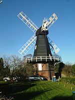
Ridley, Kent

Ridley is a place and former civil parish, now in the parish of Ash-cum-Ridley, in the Sevenoaks district, in the county of Kent, England. It lies between Sevenoaks and Chatham.. Ash and Ridley were formerly separate parishes. Both were part of Dartford Rural District and Axstane Hundred. Ridley is situated upon chalk hills, much like that of neighbouring Hartley. The soil is chalky, light and much covered with flints. There is no village and the church stands in the southern part of Ridley, having the parsonage and a lodge nearby. Ridley is 3½ miles SSW of Meopham (railway station) and 7 miles SSW of Gravesend. It has an area of 814 acres, within the bounds of the formerly separate parish.
Excerpt from the Wikipedia article Ridley, Kent (License: CC BY-SA 3.0, Authors, Images).Ridley, Kent
Ridley Hill,
Geographical coordinates (GPS) Address Nearby Places Show on map
Geographical coordinates (GPS)
| Latitude | Longitude |
|---|---|
| N 51.35025 ° | E 0.31553 ° |
Address
Ridley Hill
Ridley Hill
TN15 7EU , Ash-cum-Ridley
England, United Kingdom
Open on Google Maps


