Hamoaze
Cornwall geography stubsDevon geography stubsEngland river stubsEstuaries of EnglandGeography of Plymouth, Devon ... and 5 more
Pages with Cornish IPARiver TamarRivers of CornwallTransport in Plymouth, DevonUse British English from March 2018

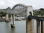
The Hamoaze (; Cornish pronunciation: [ˈhɒmøz]) is an estuarine stretch of the English tidal River Tamar, between its confluence with the River Lynher and Plymouth Sound.
Excerpt from the Wikipedia article Hamoaze (License: CC BY-SA 3.0, Authors, Images).Hamoaze
Foulston Avenue, Plymouth Barne Barton
Geographical coordinates (GPS) Address Nearby Places Show on map
Geographical coordinates (GPS)
| Latitude | Longitude |
|---|---|
| N 50.395555555556 ° | E -4.2077777777778 ° |
Address
Foulston Avenue
PL5 1HF Plymouth, Barne Barton
England, United Kingdom
Open on Google Maps


