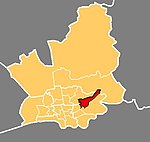
Ribbleton
Geography of PrestonWards of Preston

Ribbleton is a suburb and ward of the city of Preston, Lancashire, England. It is located to the east of the city centre, between the A59 New Hall Lane and the B6243 Longridge Road. The M6 motorway also runs through the area. The ward had a population of 7,351 recorded in the 2001 census increasing to 8,548 at the 2011 Census.
Excerpt from the Wikipedia article Ribbleton (License: CC BY-SA 3.0, Authors, Images).Ribbleton
Pope Lane, Preston Ribbleton
Geographical coordinates (GPS) Address Nearby Places Show on map
Geographical coordinates (GPS)
| Latitude | Longitude |
|---|---|
| N 53.773 ° | E -2.654 ° |
Address
Pope Lane
Pope Lane
PR2 6JN Preston, Ribbleton
England, United Kingdom
Open on Google Maps


