place

Airmyn

Civil parishes in the East Riding of YorkshireOpenDomesdayUse British English from October 2014Villages in the East Riding of Yorkshire
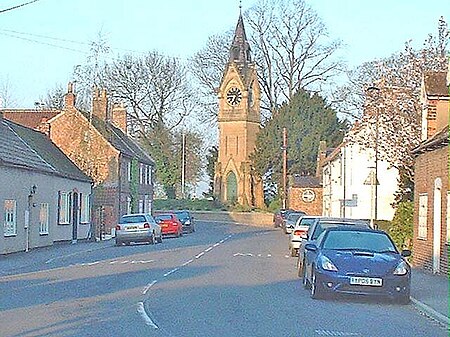
Airmyn Clock Tower
Airmyn Clock Tower

Airmyn is a village and civil parish in the East Riding of Yorkshire, England. It is situated at the mouth of the River Aire with the River Ouse, approximately 2 miles (3.2 km) north-west of Goole. It lies to the west of the M62 motorway and the A614 road. According to the 2011 UK census, Airmyn parish had a population of 768, a fall from the 2001 UK census figure of 795. The parish covers an area of 1,155.353 hectares (2,854.94 acres). The parish was part of the Goole Rural District in the West Riding of Yorkshire from 1894 to 1974, then in Boothferry district of Humberside until 1996. In the Middle Ages, Airmyn was a small port, and up to the 18th century its dead were taken by boat upstream to be buried at Snaith, as it was quicker to go by river than by horse and cart.

Excerpt from the Wikipedia article Airmyn (License: CC BY-SA 3.0, Authors, Images).

Geographical coordinates (GPS)

Latitude Longitude
N 53.719242 ° E -0.900487 °
placeShow on map

Address

Park Road

Park Road
DN14 8LP , Airmyn
England, United Kingdom
mapOpen on Google Maps

Airmyn Clock Tower
Airmyn Clock Tower
Share experience

Nearby Places

Boothferry
Boothferry

Boothferry is a village in the East Riding of Yorkshire in England. It is situated on the north bank of the River Ouse where the A614 road crosses the river. It is about 2 miles (3 km) north-west of Goole. Boothferry is split between civil parishes; areas to the west of the B1228 road are in the civil parish of Asselby, and those to the east are in Howden. Boothferry is home to Boothferry Bridge which, built in 1929, was for many years the first physical road crossing of the Ouse (if travelling inland), although a lower rail crossing was built at Goole in 1869. Boothferry Bridge was very heavily used by vehicles travelling between the north and south banks of the Humber before the opening of the M62 motorway in the mid-1970s and the Humber Bridge in 1981. Boothferry Bridge is celebrated in the song "Boothferry Bridge" written by Harvey Andrews and released in 1972 on his album 'Writer of Songs"' and by the musical group "The Lonesome Travellers", which was released in the early 1970s. The M62 now crosses the Ouse on a viaduct approximately one mile downstream (east) of the old bridge. Boothferry gave its name to the Boothferry borough of Humberside from 1974 to 1996, and to the Boothferry parliamentary constituency which, in 1997, was largely amalgamated into the Haltemprice and Howden constituency represented by David Davis MP. Boothferry was also chosen to be the name taken by a local resident when he took the title of lord in 2004. Boothferry has also lent its name to many roads and buildings along with businesses within the borough, although it is now defunct. Hull City Football Club played from 1946 to 2002 at a football stadium named Boothferry Park, which also took its name from a road (the A63 – Boothferry Road) that leads from Hull to the village.