place

Goole and District Hospital

GooleHospitals in the East Riding of YorkshireNHS hospitals in England
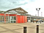
Goole and District Hospital geograph.org.uk 1776337

Goole and District Hospital is a hospital in Goole, East Riding of Yorkshire, England. It is managed by Northern Lincolnshire and Goole Hospitals NHS Foundation Trust.

Excerpt from the Wikipedia article Goole and District Hospital (License: CC BY-SA 3.0, Authors, Images).

Goole and District Hospital
Woodland Avenue,

Geographical coordinates (GPS) Address Nearby Places
placeShow on map

Wikipedia: Goole and District HospitalContinue reading on Wikipedia

Geographical coordinates (GPS)

Latitude Longitude
N 53.716556 ° E -0.874494 °
placeShow on map

Address

Woodland Avenue
DN14 6QX
England, United Kingdom
mapOpen on Google Maps

Goole and District Hospital geograph.org.uk 1776337
Share experience

Nearby Places

Howden Dyke Island
Howden Dyke Island

Howden Dyke Island is a 19-acre (7.7 ha) island in the River Ouse, Yorkshire. More accurately a shoal between seasonally varying flows, the area regularly above water (and covered in trees and vegetation) is roughly 1,380 by 890 feet (420 by 270 m). A larger example of this same feature is visible where the Ouse widens into the Humber Estuary, 12 miles (19 km) downstream at Faxfleet. The island has also been known as Hook Island and Silverpit Island, and was formerly used for agriculture, and connected to the riverbank. However, this land use combined with the digging of a fishing pond in the 1920s, eroded a channel to make an island in the 1950s, subsequently washing away soil until the island was inaccessible and, at high water, less than half its current size. Today, vegetation on the island and the riverbank opposite help to protect against erosion. The land has been used for wild-fowling, and is home to a wide range of birds and other wildlife. It forms unit 02 of the Humber Estuary Site of Special Scientific Interest, and is in favourable condition.In 2009, the island was marketed as land available for private development, at a price of £100,000. At the time the island was only accessible by boat, and a tidal range of up to six metres would inhibit habitation, other than on a special stilted construction. In 2014 the island was bought for £47,500 by the Royal Society for the Protection of Birds to protect its wildlife habitat.

Boothferry
Boothferry

Boothferry is a village in the East Riding of Yorkshire in England. It is situated on the north bank of the River Ouse where the A614 road crosses the river. It is about 2 miles (3 km) north-west of Goole. Boothferry is split between civil parishes; areas to the west of the B1228 road are in the civil parish of Asselby, and those to the east are in Howden. Boothferry is home to Boothferry Bridge which, built in 1929, was for many years the first physical road crossing of the Ouse (if travelling inland), although a lower rail crossing was built at Goole in 1869. Boothferry Bridge was very heavily used by vehicles travelling between the north and south banks of the Humber before the opening of the M62 motorway in the mid-1970s and the Humber Bridge in 1981. Boothferry Bridge is celebrated in the song "Boothferry Bridge" written by Harvey Andrews and released in 1972 on his album 'Writer of Songs"' and by the musical group "The Lonesome Travellers", which was released in the early 1970s. The M62 now crosses the Ouse on a viaduct approximately one mile downstream (east) of the old bridge. Boothferry gave its name to the Boothferry borough of Humberside from 1974 to 1996, and to the Boothferry parliamentary constituency which, in 1997, was largely amalgamated into the Haltemprice and Howden constituency represented by David Davis MP. Boothferry was also chosen to be the name taken by a local resident when he took the title of lord in 2004. Boothferry has also lent its name to many roads and buildings along with businesses within the borough, although it is now defunct. Hull City Football Club played from 1946 to 2002 at a football stadium named Boothferry Park, which also took its name from a road (the A63 – Boothferry Road) that leads from Hull to the village.