place

Jenkins–DuBois Farm

Farms on the National Register of Historic Places in New York (state)Gardiner, New YorkHouses completed in 1793National Register of Historic Places in Ulster County, New YorkUlster County, New York Registered Historic Place stubs
Jenkins DuBois Farm
Jenkins DuBois Farm

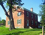
The Jenkins–DuBois Farm and Mill Site is located along Jenkinstown Road in Gardiner, Ulster County, New York, United States. It was started by settler Lambert Jenkins in 1793 with a stone house and mills on land part of the original Huguenot Patent owned by Louis DuBois of nearby New Paltz. The Jenkins–DuBois descendants still live on the land today.It was added to the National Register of Historic Places in 2001.

Excerpt from the Wikipedia article Jenkins–DuBois Farm (License: CC BY-SA 3.0, Authors, Images).

Jenkins–DuBois Farm
Jenkenstown Road,

Geographical coordinates (GPS) Address Nearby Places
placeShow on map

Wikipedia: Jenkins–DuBois FarmContinue reading on Wikipedia

Geographical coordinates (GPS)

Latitude Longitude
N 41.698333333333 ° E -74.1125 °
placeShow on map

Address

Jenkenstown Road 79
12561
New York, United States
mapOpen on Google Maps

Jenkins DuBois Farm
Jenkins DuBois Farm
Share experience

Nearby Places

Thaddeus Hait Farm
Thaddeus Hait Farm

The Thaddeus Hait Farm is located on Allhusen Road near the hamlet of Modena in the town of Plattekill, New York, United States. It is a 142-acre (0.57 km2) property on both sides of the road consisting of 15 contributing properties in two distinct groups, together comprising a mostly intact early 19th-century family farm still used for that purpose today.Hait, a member of a prosperous Westchester County family, bought the original 97 acres (39 ha) in 1819. At the time the road was the busy Milton Turnpike, carrying much traffic from distilleries. Over the next nine years, he built the farm up with purchases adding 35 acres (140,000 m2), setting it into its present form. His grandson sold it in 1888. Two other owners later, in 1906, the Allhusen family after whom the road was renamed bought it for dairy farming and kept it until 1973. After some more transitional owners, it came to the Adairs, who returned to the property's roots by going into winemaking. The farm was added to the National Register of Historic Places in 1988. They have since sold the property to Marc and Lori Stopkie, who have retained the Adair name. Today, Adair Vineyards produces 20,000 bottles annually of Seyval blanc, Vignoles, Foch and Millot, on 100 acres (40 ha). Their tasting facility is on the south side of the road east of the house.The main house, on the road a short distance from the Shuart-Van Orden Stone House, is a Federal style home built around 1825 from a mix of wood and stone, an unusual combination in that style. A frame extension of the west wing was added in the late 19th century. Originally the front was sided in clapboard with a cornice and frieze; that was replaced with cedar in the 1950s. The interior retains much of the original molding. Near the house are ancillary agricultural structures, such as a stone barn (an unusual material for the area) that appears to have built around the same time as the house, a later wood barn of an identical configuration as the first.The other group, south of the road, is centered on a New World Dutch barn, older than the main house. Originally constructed, like other Dutch barns, for wheat farming, it was adapted for winemaking around 1986. Its outbuildings include a smokehouse, icehouse and 1873 granary. An outhouse dates to the early 20th century. There is also the remains of a foundation of a late 18th or early 19th-century stone house and a well that served it.

Wallkill Valley Rail Trail

The Wallkill Valley Rail Trail is a 23.7-mile (38.1 km) rail trail and linear park that runs along the former Wallkill Valley Railroad rail corridor in Ulster County, New York, United States. It stretches from Gardiner through New Paltz, Rosendale and Ulster to the Kingston city line, just south of a demolished, concrete Conrail railroad bridge that was located on a team-track siding several blocks south of the also-demolished Kingston New York Central Railroad passenger station. The trail is separated from the Walden–Wallkill Rail Trail by two state prisons in Shawangunk, though there have been plans to bypass these facilities and to connect the Wallkill Valley Rail Trail with other regional rail-trails. The northern section of the trail forms part of the Empire State Trail.Plans to create the rail trail began as early as 1983, when New Paltz considered uses for the then-defunct Wallkill Valley rail corridor; the railroad had ceased regular traffic in 1977 and, by 1983, had begun to remove its tracks. In 1991, a local land trust, the Wallkill Valley Land Trust, purchased the 12-mile (19 km) section of the former rail corridor between New Paltz and Gardiner, and conveyed the New Paltz section to the town and village of New Paltz with permanent land protection agreements, held by the Wallkill Valley Land Trust. The trail was formally opened between New Paltz and Gardiner in 1993, though Gardiner did not purchase its section from the Wallkill Valley Land Trust until 2007: again, with a land protection agreement placed on it. The length of the trail was effectively doubled by an Ulster County unpaid-tax foreclosure land seizure, in 2009. The Wallkill Valley Land Trust, in partnership with Open Space Institute, acquired the additional property from Ulster County and began several capital campaigns to open-up public access. The extension included the Rosendale trestle, a 940-foot (290 m) bridge across Rondout Creek. There are several other bridges that carry the trail, though none are as long. The trail serves hikers, joggers, bikers, horseback riders and cross-country skiers. It passes through several historic districts, such as Huguenot Street in New Paltz, and the Binnewater Historic District and Snyder Estate in Rosendale. The trail also traverses U.S. Route 44 (concurrent with State Route 55), and state routes 299 and 213. Several natural features are visible from clear points along the trail, such as the Shawangunk Ridge to the west and the Plattekill Creek between New Paltz and Gardiner. The trail passes through dense vegetation, and is frequented by many types of animals and overwintering birds.

Gardiner Town Hall
Gardiner Town Hall

The Town of Gardiner, in Ulster County, New York, United States uses the former Gardiner Schoolhouse as its town hall. It is located on US 44/NY 55 at the east end of the hamlet of Gardiner, and houses all the departments of town government, the town court and a branch office of the New York State Police. It is built in the Queen Anne style, painted green and white. The building began life as a one-room schoolhouse rolled into the hamlet on logs in 1875. Fifty years later it was one of the few buildings to survive a fire that destroyed many other buildings in the community. It remained in use as a school, expanded to two rooms, until 1981.The town began using it shortly afterwards, but it served mainly as a meeting place for the town board. Other offices were housed elsewhere in the town, often at the firehouse across the road and an office plaza downtown. In 2000 it was added to the National Register of Historic Places, and the town began to seriously consider renovating and expanding it. Some residents did not believe that was necessary, and helped defeat a $1.5 million expansion plan in a March 2001 vote. A vote later that year limited the town to $850,000 for any renovation or construction.Three years later, a new town supervisor, Carl Zatz, initiated a project to renovate and expand the building. It caused some controversy when other town officials and residents publicly expressed doubts that the work could be done for the minimal costs Zatz claimed it would. It was completed for what Zatz's Democratic Party says was less than budgeted. Republican opponents, however, criticized him for destroying the school's outhouse in the process.