place

Edgewater, New Jersey
1894 establishments in New JerseyBorough form of New Jersey governmentBoroughs in Bergen County, New JerseyColonial settlements in North AmericaEdgewater, New Jersey
New Jersey populated places on the Hudson RiverPopulated places established in 1894Use American English from March 2020Use mdy dates from March 2020
Edgewater development

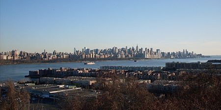
Edgewater is a borough located along the Hudson River in Bergen County, in the U.S. state of New Jersey. As of the 2020 United States census, the borough's population was 14,336, an increase of 2,823 (+24.5%) from the 2010 census count of 11,513, which in turn reflected an increase of 3,836 (+50.0%) from the 7,677 counted in the 2000 CensusThe borough's history has featured the founding of the first colony in Bergen County, contribution to the Revolutionary War, a period as a "sleepy, pastoral little town" with resort hotels in the 19th century, industrialization in the early 20th century, and a transition to a rapidly growing residential community in the late 20th century.Edgewater was incorporated as a municipality on December 7, 1894, from portions of Ridgefield Township as the Borough of Undercliff, based on the results of a referendum that passed two days earlier. The borough was formed during the "Boroughitis" phenomenon then sweeping through Bergen County, in which 26 boroughs were formed in the county in 1894 alone. The borough's name was changed to Edgewater on November 8, 1899. The borough was named for its location on the Hudson River.

Excerpt from the Wikipedia article Edgewater, New Jersey (License: CC BY-SA 3.0, Authors, Images).

Edgewater, New Jersey
River Road,

Geographical coordinates (GPS) Address Nearby Places
placeShow on map

Wikipedia: Edgewater, New JerseyContinue reading on Wikipedia

Geographical coordinates (GPS)

Latitude Longitude
N 40.82465 ° E -73.973793 °
placeShow on map

Address

Whole Foods Market

River Road
07020
New Jersey, United States
mapOpen on Google Maps

Edgewater development
Share experience

Nearby Places

Edgewater Public Schools

The Edgewater Public Schools is a community public school district that serves students in kindergarten through sixth grades from Edgewater, in Bergen County, New Jersey, United States.As of the 2018–19 school year, the district, comprising two schools, had an enrollment of 1,022 students and 70.3 classroom teachers (on an FTE basis), for a student–teacher ratio of 14.5:1. With district enrollment increasing rapidly, George Washington School opened in September 2012, having been constructed with a third floor to accommodate enrollment growth in the district that was anticipated to rise from 628 in 2011 to as much as 925 in 2015.The district is classified by the New Jersey Department of Education as being in District Factor Group "GH", the third-highest of eight groupings. District Factor Groups organize districts statewide to allow comparison by common socioeconomic characteristics of the local districts. From lowest socioeconomic status to highest, the categories are A, B, CD, DE, FG, GH, I and J.For seventh through twelfth grades, public school students from the borough are sent to the Leonia Public Schools as part of a sending/receiving relationship. Schools in the district attended by Edgewater students (with 2018–19 enrollment data from the National Center for Education Statistics) are Leonia Middle School with 533 students in grades 6 - 8 (Edgewater students attend for grades 7&8) and Leonia High School with 740 students in grades 9 - 12.

Vriessendael, New Netherland

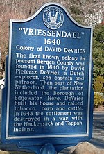
Vriessendael was a patroonship on the west bank of the Hudson River in New Netherland, the seventeenth century North American colonial province of the Dutch Empire. The homestead or plantation was located on a tract of about 500 acres (2.0 km2) about an hour's walk north of Communipaw at today's Edgewater. It has also been known as Tappan, which referred to the wider region of the New Jersey Palisades, rising above the river on both sides of the New York/New Jersey state line, and to the indigenous people who lived there and were part of wider group known as Lenape (later called Delaware Indian). It was established in 1640 by David Pietersen de Vries (c. 1593-c.1655), a Dutch sea captain, explorer, and trader who had also established settlements at the Zwaanendael Colony and on Staten Island. The name can roughly be translated as De Vries' Valley. De Vries also owned flatlands along the Hackensack River, in the area named by the Dutch settlers Achter Col. Parts of Vriessendael were destroyed in 1643 in reprisal for the slaughter of Tappan and Wecquaesgeek Native Americans who had taken refuge at Pavonia and Corlears Hook. The patroon's relatively good relations with the Lenape prevented the murder of the plantation's residents, who were able to seek sanctuary in the main house, and later flee to New Amsterdam. The incident was one of the first of many to take place during Kieft's War, a series of often bloody conflicts with bands of Lenape, who had united in face of attacks ordered by the Director of New Netherland.