place

Charlton Marshall Halt railway station

Disused railway stations in DorsetFormer Somerset and Dorset Joint Railway stationsPages with no open date in Infobox stationRailway stations in Great Britain closed in 1956Railway stations in Great Britain opened in 1928
South West England railway station stubsUse British English from May 2017
Charlton Marshall Halt Station

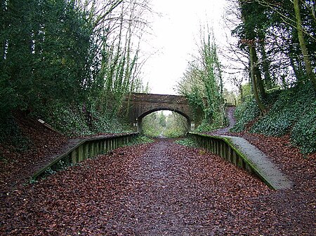
Charlton Marshall Halt was a station in the English county of Dorset. It was located between Blandford Forum and Bailey Gate on the Somerset and Dorset Joint Railway. The station consisted of two short platforms and shelters.

Excerpt from the Wikipedia article Charlton Marshall Halt railway station (License: CC BY-SA 3.0, Authors, Images).

Charlton Marshall Halt railway station
Cereleton Park,

Geographical coordinates (GPS) Address Nearby Places
placeShow on map

Wikipedia: Charlton Marshall Halt railway stationContinue reading on Wikipedia

Geographical coordinates (GPS)

Latitude Longitude
N 50.83537 ° E -2.14701 °
placeShow on map

Address

Cereleton Park

Cereleton Park
DT11 9PN
England, United Kingdom
mapOpen on Google Maps

Charlton Marshall Halt Station
Share experience

Nearby Places

Blandford St Mary
Blandford St Mary

Blandford St Mary is a village and civil parish in the North Dorset district of Dorset, England. The village is on the south bank of the River Stour, immediately opposite the larger town of Blandford Forum. The village grew up around the Badger Brewery, owned by Hall and Woodhouse, which is based there. At the 2001 census it had a population of 1,233. The appropriate electoral ward is called 'Portman' with naturally the most populous area being south of the river. The ward includes Bryanston School and also runs south west almost to Thornicombe. The total ward population at the abovementioned census was 2,436.Blandford St Mary has a busy Tesco supermarket and fuel station and a Homebase DIY store which attracts shoppers from the many villages that surround the Blandford area. In addition there are a number of offices in Stour Park. In the residential area there is a new housing estate and primary school. An older area of the village near the river bridge to Blandford Forum has a traditional public house and a village green. Opposite is the old stone gate at the entrance of the Bryanston School estate. Outline planning permission has been given to redevelop the Hall & Woodhouse brewery site to include new offices and 200 new homes. Lower Blandford St Mary is a rural outpost of Blandford St Mary, in the farm fields to the south across the bypass road, with a small church and graveyard, and one or two historic houses. The Dorset Central Railway, which opened on 1 November 1860 from the LSWR station at Wimborne, had a station in the village, serving the neighbouring important market town of Blandford Forum. This was demolished when the line amalgamated to be part of the Somerset & Dorset Railway, and a bridge was built over the river Stour to the station at Blandford.

River Tarrant
River Tarrant

The River Tarrant is a 12 km long tributary of the River Stour in Dorset. The valley lies to the east of Blandford Forum. The river rises near Cranborne Chase, an area of chalk downland, and flows broadly from north to south before joining the river Stour. The eight Tarrant Valley villages/hamlets all bear the name of the river. Listed in order from the river's source they are: Tarrant Gunville: the source of the river is in the grounds of Gunville House, now demolished. The parish church is dedicated to St Mary. Tarrant Hinton: a village at a crossroads. The parish church is dedicated to St Mary. Tarrant Launceston: a hamlet with a 17th-century three-arched bridge. The church, dedicated to St Mary, was demolished in the 1700s (the site is on Higher Dairy Farm). Now part of the parish of Tarrant Monkton. Tarrant Monkton: a village with a parish church dedicated to All Saints. Tarrant Rawston: a very small settlement. This once had a parish church dedicated to St Mary, which still exists and is in private ownership but remains as a church. Tarrant Rushton: a village with a parish church dedicated to St Mary. Near here was a World War II RAF airfield. Tarrant Keyneston: this is the largest village of the eight; it has a parish church dedicated to All Saints. Tarrant Crawford, the final settlement, lies at the confluence of the rivers Tarrant and Stour. Here there is the church of St Mary the Virgin held by the Churches Conservation Trust and Tarrant Abbey farm, where once stood a nunnery. Tarrant Crawford became part of the parish of Tarrant Keyneston.There were possibly one or two other Tarrant communities: Tarrant Stubhampton, north of Tarrant Gunville and part of that parish: This is now known as Stubhampton. In the Middle Ages, a church existed in that village. This is the source of the Tarrant. Tarrant Antioch which may have been an earlier name for Tarrant Rawston, or may have been a distinct community just north of Tarrant Rawston. Tarrant Antioch was served by St Mary Tarrant Crawford, where there was a devotion to St Margaret of Antioch. Tarrant Preston, now Preston FarmA Roman road followed the valley and there are many tumuli on the hills on both sides of the river, evidence of long occupation.