place

Maspeth, Queens

1642 establishments in the Dutch EmpireHistoric Romani communitiesMaspeth, QueensNeighborhoods in Queens, New YorkPages with non-numeric formatnum arguments
Use mdy dates from May 2015
Maspeth Fed Savings Grand 69 jeh

Maspeth is a residential and commercial community in the borough of Queens in New York City. It was founded in the early 17th century by Dutch and English settlers. Neighborhoods sharing borders with Maspeth are Woodside to the north; Sunnyside to the northwest; Greenpoint, Brooklyn to the west; East Williamsburg, Brooklyn to the southwest; Fresh Pond and Ridgewood to the south; and Middle Village and Elmhurst to the east. Maspeth is located in Queens Community District 5 and its ZIP Code is 11378. It is patrolled by the New York City Police Department's 104th Precinct. Politically, Maspeth is represented by the New York City Council's 29th and 30th Districts.

Excerpt from the Wikipedia article Maspeth, Queens (License: CC BY-SA 3.0, Authors, Images).

Maspeth, Queens
Front Avenue, New York Brooklyn

Geographical coordinates (GPS) Address Nearby Places
placeShow on map

Wikipedia: Maspeth, QueensContinue reading on Wikipedia

Geographical coordinates (GPS)

Latitude Longitude
N 40.705 ° E -73.975 °
placeShow on map

Address

Pier C

Front Avenue
11251 New York, Brooklyn
New York, United States
mapOpen on Google Maps

Maspeth Fed Savings Grand 69 jeh
Share experience

Nearby Places

Brooklyn Navy Yard
Brooklyn Navy Yard

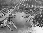
The Brooklyn Navy Yard (originally known as the New York Navy Yard) is a shipyard and industrial complex located in northwest Brooklyn in New York City, New York. The Navy Yard is located on the East River in Wallabout Bay, a semicircular bend of the river across from Corlears Hook in Manhattan. It is bounded by Navy Street to the west, Flushing Avenue to the south, Kent Avenue to the east, and the East River on the north. The site, which covers 225.15 acres (91.11 ha), is listed on the National Register of Historic Places. The Brooklyn Navy Yard was established in 1801. From the early 1810s through the 1960s, it was an active shipyard for the United States Navy, and was also known as the United States Naval Shipyard, Brooklyn and New York Naval Shipyard at various points in its history. The Brooklyn Navy Yard produced wooden ships for the U.S. Navy through the 1870s, and steel ships after the American Civil War in the 1860s. The Brooklyn Navy Yard has been expanded several times, and at its peak, it covered over 356 acres (1.44 km2). The efforts of its 75,000 workers during World War II earned the yard the nickname "The Can-Do Shipyard". The Navy Yard was deactivated as a military installation in 1966, but continued to be used by private industries. The facility now houses an industrial and commercial complex run by the New York City government, both related to shipping repairs and maintenance and as office and manufacturing space for non-maritime industries. The Brooklyn Navy Yard includes dozens of structures, some of which date to the 19th century. The Brooklyn Naval Hospital, a medical complex on the east side of the Brooklyn Navy Yard site, served as the yard's hospital from 1838 until 1948. Dry Dock 1, one of six dry docks at the yard, was completed in 1851 and is listed as a New York City designated landmark. Former structures include Admiral's Row, a grouping of officers' residences at the west end of the yard, which was torn down in 2016 to accommodate new construction. Several new buildings were built in the late 20th and early 21st centuries as part of the city-run commercial and industrial complex. A commandant's residence, also a National Historic Landmark, is located away from the main navy yard's site. The FDNY's Marine Operations Division and their fireboats are located at Building 292.