place

Agbrigg

Suburbs of WakefieldUse British English from October 2014
Agbrigg shops on north side of Doncaster Road

Agbrigg is a suburb of the city of Wakefield, West Yorkshire, England.

Excerpt from the Wikipedia article Agbrigg (License: CC BY-SA 3.0, Authors, Images).

Agbrigg
Wentworth Way, Wakefield Sandal Magna

Geographical coordinates (GPS) Address Nearby Places
placeShow on map

Wikipedia: AgbriggContinue reading on Wikipedia

Geographical coordinates (GPS)

Latitude Longitude
N 53.66 ° E -1.48 °
placeShow on map

Address

Wentworth Way
WF2 6QX Wakefield, Sandal Magna
England, United Kingdom
mapOpen on Google Maps

Agbrigg shops on north side of Doncaster Road
Share experience

Nearby Places

Chantry Bridge
Chantry Bridge

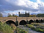
Chantry Bridge, sometimes known as Wakefield Bridge, is a mediaeval bridge in the city of Wakefield, in West Yorkshire, in England. In the early 14th century, there was a timber bridge over the River Calder in Wakefield, with Kirkgate connecting the bridge to the town centre. The bridge was damaged by flooding in the 1330s, and a decision was taken to rebuild it in stone.Construction of the new bridge began in 1342, with spans connecting the north bank to a small island. The Chantry Chapel of St Mary the Virgin was built on the island. The bridge was then completed from the island to the south bank, in similar style, but only the arches supporting the northern part of the bridge have ribs. The chapel was consecrated in 1356, and this is sometimes taken to be the completion date of the bridge. The bridge was widened by nine feet in 1758. It was painted by J. M. W. Turner in 1797, in which year it was widened by nine feet for a second time. This work was probably designed by John Carr of York and undertaken by Bernard Hartley. Wakefield New Bridge was constructed immediately upstream of Chantry Bridge in 1933, and now carries the large majority of traffic. Chantry Bridge was Grade I listed in 1953. The bridge has nine arches. The original arches are visible on the downstream side, and are pointed, while the widened section on the upstream side has round arches. Each arch is supported by a platform with a cutwater. There is a plain parapet.

Walton, Wakefield
Walton, Wakefield

Walton is a village and civil parish in the City of Wakefield in the county of West Yorkshire, England, 4 miles south-east of Wakefield. At the time of the 2011 Census, the parish had a population of 3,231. At the time of the 2011 Census the parish was part of the City of Wakefield's ward of Crofton, Ryhill and Walton. The population of this ward at the Census was 15,144.Historically part of the West Riding of Yorkshire, the village lies on the Barnsley Canal and is home to Walton Hall, once the residence of Charles Waterton, known as 'Squire' Waterton. He was a naturalist and explorer who, in 1820, transformed the grounds of the Walton Hall estate the world's first nature reserve. The estate is also often referred to on Ordnance Survey maps, etc., as Walton Park and, less frequently, as Walton Hall Park. More recently, it has become widely known as Waterton Park. Walton Hall is now Waterton Park Hotel. The park is now largely given over to a golf course, also named Waterton Park. There are public rights of way crossing the park. Nearby, the site of the now demolished Walton Colliery, formerly known as Sharlston West colliery, has been transformed into a nature park (Walton Colliery Nature Park). Large lakes were constructed when the reserve was landscaped in the mid-1990s and the excavated earth was then used to cover the colliery's vast spoil heaps. The village also contains a small park, a tennis club, football and rugby pitches, a newly renovated pub and a sports and social club.