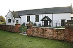
Barrets Green
Cheshire geography stubsVillages in Cheshire
Barrets Green is a small settlement in the unitary authority of Cheshire East and the ceremonial county of Cheshire, England. It lies on the A51 (Nantwich Road) at SJ59075925, by the junction with Long Lane (to Wettenhall), at an elevation of 56 metres. Local farms include Barrets Green Farm and The Grange. For administrative purposes, Barrets Green falls mainly within the civil parish of Alpraham, with a small part in Calveley; it is approximately 1⁄4 miles from each of these two villages.As of 2016, Barrets Green is served by the Arriva North West Chester–Crewe bus route 84, with a stop near the Long Lane junction on the A51.
Excerpt from the Wikipedia article Barrets Green (License: CC BY-SA 3.0, Authors).Barrets Green
Long Lane,
Geographical coordinates (GPS) Address Nearby Places Show on map
Geographical coordinates (GPS)
| Latitude | Longitude |
|---|---|
| N 53.128878 ° | E -2.613078 ° |
Address
Long Lane
Long Lane
CW6 9JY , Alpraham and Calveley
England, United Kingdom
Open on Google Maps


