place

Billington Sea

Neighborhoods in Plymouth, MassachusettsPonds of MassachusettsPonds of Plymouth, Massachusetts
Town Brook Billington Sea Plymouth MA

Billington Sea (also Billington's Sea) is a 269-acre (1.09 km2) warm water pond located in Plymouth, Massachusetts. Morton Park lies on the pond's northern shore. The pond is fed by groundwater and cranberry bog outlets. The average depth is seven feet and the maximum depth is 11 feet (3.4 m). The pond provides the headwaters to Town Brook. Seymour Island is located in the center of the pond. Billington Sea was named after its discoverer, Francis Billington, one of the passengers on the Mayflower.

Excerpt from the Wikipedia article Billington Sea (License: CC BY-SA 3.0, Authors, Images).

Billington Sea
Morton Park Road, Plymouth

Geographical coordinates (GPS) Address Nearby Places
placeShow on map

Wikipedia: Billington SeaContinue reading on Wikipedia

Geographical coordinates (GPS)

Latitude Longitude
N 41.941666666667 ° E -70.676666666667 °
placeShow on map

Address

Morton Park Road

Morton Park Road
02360 Plymouth
Massachusetts, United States
mapOpen on Google Maps

Town Brook Billington Sea Plymouth MA
Share experience

Nearby Places

Town Brook Historic and Archeological District

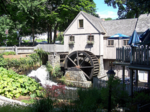
The Town Brook Historic and Archeological District is a historic district encompassing much of the length of Town Brook and its surrounding landscape in Plymouth, Massachusetts. This area has an industrial history that extends to 1620, when the Pilgrims arrived on the Mayflower and established Plymouth Colony. It extends roughly from the crossing of Billington Street (near where it crosses Massachusetts Route 3), to the mouth of the brook in Plymouth Harbor. The district was listed on the National Register of Historic Places in 1995.The district includes historical and archaeological resources that span more than three centuries. Included in these resources are four mill ponds, dams, herring runs, mill privileges (sites where mill operators were authorized to divert water, where industrial archaeological remains may be found), and a variety of housing from nearly every significant period in that time. The oldest house in the district is the Richard Sparrow House built in 1640; it is also the oldest building standing in Plymouth. The mills erected by the early settlers were used to saw wood and grind grain. As Plymouth prospered and grew, smaller industrial operations harnessed the brook's water power to perform other functions. During the 19th century, the nation's industrialization reached Town Brook, and mill complexes of larger size were also built. Around the turn of the 20th century, mills were established for processing iron in a variety of ways, some of whose buildings still survive today. A significant number of industrial properties from the 19th century were lost in the 20th century, often to fire. Interest in the area's rich history led to the establishment in the 1920s of Brewster Gardens, a public park near the mouth of the brook. Near the park is the Jenney Grist Mill, a 1970 reconstruction of an early grist mill which burned in 1837.