Clevelode
AC with 0 elementsVillages in WorcestershireWorcestershire geography stubs

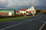
Clevelode is a small village in Worcestershire, England. It is located around 5 miles south of Worcester just to the west of the River Severn. Clevelode is next to the B4244 between Callow End and Hanley Castle in the civil parish of Powick. A caravan park and bed and breakfast are located just south of Clevelode.
Excerpt from the Wikipedia article Clevelode (License: CC BY-SA 3.0, Authors, Images).Clevelode
Upton Road, Malvern Hills District
Geographical coordinates (GPS) Address Nearby Places Show on map
Geographical coordinates (GPS)
| Latitude | Longitude |
|---|---|
| N 52.123095 ° | E -2.254601 ° |
Address
Upton Road
Upton Road
WR13 6PD Malvern Hills District
England, United Kingdom
Open on Google Maps


