Ramapo, New York

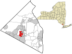
Ramapo is a town in Rockland County, New York, United States. It was originally formed as New Hampstead, in 1791, and became Ramapo in 1828. It shares its name with the Ramapo River. As of the 2020 census, Ramapo had a total population of 148,919, making it the most populous town in New York outside of Long Island. If Ramapo were incorporated as a city, it would be the sixth-largest city in the state of New York. The town's name, recorded variously as Ramopuck, Ramapock, or Ramapough, is of Lenape origin, meaning either "sweet water" or "slanting rocks". Early maps referred to Ramapo as Ramepog (1695), Ramepogh (1711), and Ramapog (1775).The town is located south of Haverstraw and west of Clarkstown and Orangetown.
Excerpt from the Wikipedia article Ramapo, New York (License: CC BY-SA 3.0, Authors, Images).Ramapo, New York
Locust Hollow Drive, Town of Ramapo
Geographical coordinates (GPS) Address Nearby Places Show on map
Geographical coordinates (GPS)
| Latitude | Longitude |
|---|---|
| N 41.121944444444 ° | E -74.083333333333 ° |
Address
Locust Hollow Drive 14
10952 Town of Ramapo
New York, United States
Open on Google Maps


