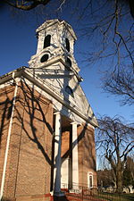
The recorded history of Rockland County, New York begins on February 23, 1798, when the county was split off from Orange County, New York and formed as its own administrative division of the state of New York. It is located 6 miles (9.7 km) north-northwest of New York City, and is part of the New York Metropolitan Area. The county seat is the hamlet of New City. The name comes from rocky land, an early description of the area given by settlers. Rockland is New York's southernmost county west of the Hudson River. It is suburban in nature, with a considerable amount of scenic designated parkland. Rockland County does not border any of the New York City boroughs, but is only 9.5 miles (15.3 km) north of Manhattan at the counties' (New York and Rockland) two respective closest points (Palisades, New York, in Rockland and Inwood Park in Manhattan)
Most of the early settlers were Dutch, with a sprinkling of Huguenot and Quaker families. The settlers lived almost entirely off the land, farming – berries, fruits and vegetables, as well as hunting, fishing, and trapping.
Early attempts to settle the county by the Dutch were generally unsuccessful, and in 1664 they handed over the territory to the English. Yet the Dutch did leave a legacy in place names like Dunderberg Mountain, Sparkill and High Tor, as well as a small collection of unique sandstone houses like the 1700 DeWint House, built in Tappan and still exists, which later served as George Washington’s headquarters.
During the American Revolutionary War, Rockland County was a strategic crossroads, camping ground and vital link between the northern and southern colonies. Troops often used Kings Ferry at Stony Point and Dobbs Ferry at Snedens Landing in Palisades. The first post office in Rockland County was established at New Antrim, now Suffern, on October 4, 1797.
By 1800, the total population of the newly created County of Rockland was nearly 6,400. The land was cleared, homes, schools and churches were built and sawmills and gristmills erected along the numerous creeks.
By 1828, Native Americans had virtually disappeared from the county and slavery existed in a diminished form.


