place

Pelham Islands

Geography of New Rochelle, New YorkGeography of the BronxIslands of New York CityIslands of Westchester County, New YorkIslands of the Bronx
Long Island Sound
IslandsMap
IslandsMap

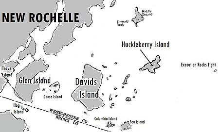
The Pelham Islands are a group of islands in western Long Island Sound that belonged to Thomas Pell in the 17th century. The islands, and most of the surrounding area, were purchased from the Siwanoy Indians by Pell in 1654, creating Pelham Manor. This large tract of land would eventually become the present-day Town and Village of Pelham and Pelham Manor, Town of Eastchester, cities of New Rochelle and Mount Vernon in Westchester County, and the Pelham Bay and Eastchester neighborhoods of the Bronx in New York City. Several of the Pelham Islands became part of New Rochelle after Jacob Leisler’s purchase of 6,000 acres (2,400 hectares) from the Pell family in 1688. The remaining islands became part of Bronx County in 1895 with the establishment of the current Westchester-Bronx County line.

Excerpt from the Wikipedia article Pelham Islands (License: CC BY-SA 3.0, Authors, Images).

Pelham Islands
McCrea Road,

Geographical coordinates (GPS) Address Nearby Places
placeShow on map

Wikipedia: Pelham IslandsContinue reading on Wikipedia

Geographical coordinates (GPS)

Latitude Longitude
N 40.883417 ° E -73.770231 °
placeShow on map

Address

McCrea Road

McCrea Road
10805
New York, United States
mapOpen on Google Maps

IslandsMap
IslandsMap
Share experience

Nearby Places

Columbia Island (New York)

Columbia Island (formerly Little Pea Island), is an island in the Long Island Sound and part of New Rochelle, New York. It is situated off the south-eastern coast of Davids' Island, immediately adjacent to Pea Island. The island varies in size from about one acre to 175 square feet depending on the tide. It was once owned by the Iselin family who sold it to the Huguenot Yacht Club along with Pea Island in 1936. Three years later the club sold Little Pea Island to the Columbia Broadcasting System, which appropriately renamed it "Columbia". As a result of engineering surveys designating the area around New Rochelle and Port Washington on Long Island Sound as the ideal locality for a radio transmitter to serve the metropolitan New York area, new stations were constructed on these sites by both the Columbia ("CBS") and National ("NBC") broadcasting systems in 1940. CBS purchased the island as the site for a new broadcast antenna tower for WCBS (then known by the call sign WABC).CBS spent approximately $500,000 to construct the transmitter building with emergency housing for ten workers, and the 410-foot (125 m) broadcast tower. The station contained a 50,000-watt transmitter housed in a 75-square-foot (7.0 m2) copper-walled building. There also was a 5,000-watt transmitter unit for emergency use. Electric power was supplied through two submarine cables, which were connected to separate power plants to prevent interruption of service. Emergency generators were installed on the island for protection against power failure. The men who operated the station lived within a grounded metal shell under which were living quarters for engineers, workshops, electrical units that supplied tube voltages, and the backup generator. The transmitter remained in operation until 1963, when it became obsolete, and the station was moved to nearby High Island. CBS's work to build a high-power broadcasting station included drilling through bedrock to a source of fresh water, found at a depth of 910 feet (280 m).The island was then purchased by the show-business couple Peter Lind Hayes and Mary Healy, who broadcast a breakfast conversation show from their home there. It was part of a package that included a strip of waterfront property, a speedboat, and a tugboat. The couple later gave the island to the College of New Rochelle. In 2005, the then-current owner of the island sought to demolish the old transmitter building and replace it with a private residence. Pathologist Al Sutton bought Columbia Island in 2007. To make the island more livable, he constructed an off-the-grid "green" home within the concrete building with solar panels. In June 2019, Columbia Island and nearby Pea island were jointly put on sale with a list price of $13 million. According to The New York Times Sutton described the property as a "money pit". Sutton spent $8 million on the property.
New Rochelle Harbor (Long Island Sound)

New Rochelle Harbor is the name of a harbor located along Long Island Sound in the city of New Rochelle in Westchester County, New York. The Davenport Neck peninsula off the mainland divides New Rochelle's waterfront into two bays; the westerly referred to as New Rochelle Harbor and the easterly as Echo Bay. The upper portion the harbor lying behind Davenport’s Neck is known as "New Rochelle Creek". It extends in a northerly direction about a mile from the main entrance to the harbor east of Glen Island. Titus Mill-Pond is located at the northeastern end of the creek. The "Lower Harbor" is the long, narrow channel between Travers, Neptune and Glen islands. The entire harbor is protected from rough water and storms in Long Island Sound by Davenport Neck, Glen Island, and Hunters Island.The Lower Harbor area is the site of a considerable amount of boating activity since it contains the mooring areas of the New York Athletic Club on Travers Island, and the Huguenot Yacht Club, and boatyards on the southerly half of Neptune Island. Also using the waters of the Lower Harbor are two boat launching ramps at Glen Island Park. The inner portion of the harbor is used by only a few boats, since most of its waters do not have sufficient depth. The harbor has a length of about 6,500 feet and width of from 500 to 600 feet. The main entrance channel to the harbor lies between Davenport Neck and Glen Island. Access to the Lower Harbor from this entrance also involves passing under a bascule bridge connecting Glen Island to the mainland. Every time a boat enters or leaves the Lower Harbor, it requires the opening of the bridge, thus necessitating twenty-four-hour bridge tender staffing. A second entrance channel, between Glen Island and Hunters Island. Other channels exist between the several islands which lie on the Long Island Sound side of the harbor and protect the latter from easterly storms. Of these channels, one passes between Glen Island and Goose Island and another lies between Davids Island and Goose Island. The waters surrounding and in the immediate vicinity of these islands as well as the entrance channels are obstructed by numerous rocks.The shoreline of New Rochelle Harbor contains a mix of recreational and marine commercial uses, and medium and high-density residential development. Recreational uses are predominant in the Lower Harbor, and include: Glen Island County Park, Glen Island Yacht Club, the New York Athletic Club Yacht Club, Huguenot Yacht Club. Additional marinas are arranged along the shoreline, with commercial and residential uses situated along Pelham Road in the upper harbor area.