Ashley Down
Areas of Bristol
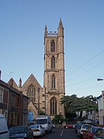
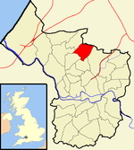
Ashley Down is an area in the north of Bristol. It lies on high ground east of Bishopston, north of St Andrews and St Werburghs, west of Muller Road and south of Horfield. The main artery is Ashley Down Road. Since May 2016 it is part of the Bishopston & Ashley Down ward of Bristol City Council. Ashley Down was developed in Victorian times. A number of large detached villas were built on Ashley Down Road. Smaller terraced houses were built in the north of the district.
Excerpt from the Wikipedia article Ashley Down (License: CC BY-SA 3.0, Authors).Ashley Down
Ashgrove Avenue, Bristol Ashley Down
Geographical coordinates (GPS) Address Nearby Places Show on map
Geographical coordinates (GPS)
| Latitude | Longitude |
|---|---|
| N 51.48 ° | E -2.58 ° |
Address
Ashgrove Avenue 17
BS7 9LJ Bristol, Ashley Down
England, United Kingdom
Open on Google Maps


