place

Troy, New Hampshire

Towns in Cheshire County, New HampshireTowns in New HampshireTroy, New HampshireUse mdy dates from July 2023
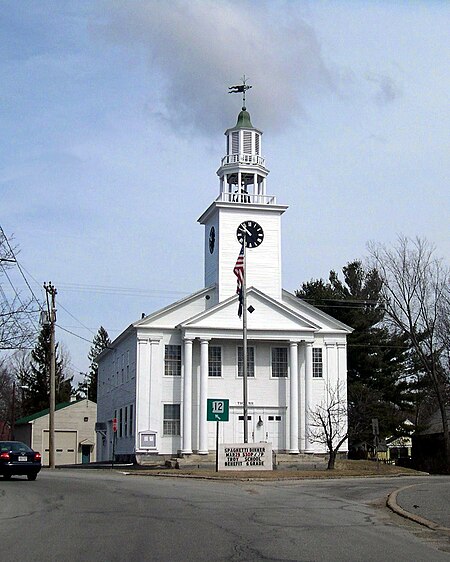
Troy Meeting House
Troy Meeting House

Troy is a town in Cheshire County, New Hampshire, United States. The population was 2,130 at the 2020 census. It is situated west of Mount Monadnock. The town's central village, where 1,108 people resided at the 2020 census, is defined as the Troy census-designated place (CDP), and is located along New Hampshire Route 12. The center of the CDP is listed on the National Register of Historic Places as the Troy Village Historic District.

Excerpt from the Wikipedia article Troy, New Hampshire (License: CC BY-SA 3.0, Authors, Images).

Troy, New Hampshire
Water Street,

Geographical coordinates (GPS) Address Nearby Places
placeShow on map

Wikipedia: Troy, New HampshireContinue reading on Wikipedia

Geographical coordinates (GPS)

Latitude Longitude
N 42.825 ° E -72.183611111111 °
placeShow on map

Address

Water Street 63
03465
New Hampshire, United States
mapOpen on Google Maps

Troy Meeting House
Troy Meeting House
Share experience

Nearby Places

Troy Village Historic District

The Troy Village Historic District is a historic district encompassing the historic village center of Troy, New Hampshire, United States. The district is centered along New Hampshire Route 12, north to Marlborough Road and south to the junction with South Main Street. To the east of NH 12 it includes School Street, Mill Street, and Monadnock Street as far as Mill Street, and most of the abutting streets. On the west side it includes Russell, Water, and Prospect streets, and South Main Street nearly to Longmeadow Drive. It was listed on the National Register of Historic Places in 2002.The village is dominated by residential construction, which mainly consists of 1.5 and 2.5 story wood-frame houses built between about 1850 and the early decades of the 20th century. The village grew where it is because of the ready access to water power, provided by several streams which merge to form the South Branch of the Ashuelot River. Troy was incorporated out of parts of Marlborough and Fitzwilliam in 1815. The heart of the town is its common, created when the town was incorporated. Its economic activity was focused on the mill complexes that developed on Mill Street and Monadnock Street. These initially produced wood products, but in the second half of the 19th century, the greatest period of Troy's growth, textile processing became increasingly important. Business benefited from the arrival of the railroad in the late 1840s, which also brought tourists to the area.

Mount Monadnock
Mount Monadnock

Mount Monadnock, or Grand Monadnock, is a mountain in the towns of Jaffrey and Dublin, New Hampshire. It is the most prominent mountain peak in southern New Hampshire and is the highest point in Cheshire County. It lies 38 miles (61 km) southwest of Concord and 62 miles (100 km) northwest of Boston. At 3,165 feet (965 m), Mount Monadnock is nearly 1,000 feet (305 m) higher than any other mountain peak within 30 miles (48 km) and rises 2,000 feet (610 m) above the surrounding landscape. Monadnock's bare, isolated, and rocky summit provides expansive views. It is known for being featured in the writings of Ralph Waldo Emerson and Henry David Thoreau. Mt. Monadnock has long been cited as one of the most frequently climbed mountains in the world. It bears a number of hiking trails, including the 110-mile (180 km) Metacomet-Monadnock Trail and the 50-mile (80 km) Monadnock-Sunapee Greenway. The summit is barren largely because of fires set by early settlers. The first major fire, set in 1800 to clear the lower slopes for pasture, swept through the stands of virgin red spruce on the summit and flanks of the mountain. Between 1810 and 1820, local farmers, who believed that wolves were denning in the blowdowns, set fire to the mountain again. The conflagration raged for weeks, destroying the topsoil and denuding the mountain above 2,000 feet (610 m).The term "monadnock" is used by American geologists to describe any isolated mountain formed from the exposure of a harder rock as a result of the erosion of a softer one once surrounding it (a landform termed "inselberg" ("island-peak") elsewhere in the world).