Johor Bahru District

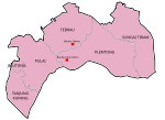
The Johor Bahru District is a district located in the southern part of Johor, Malaysia. The heavily suburban/suburbanizing district covers an area of 1,063.97 km2 (410.80 sq mi) and has a population of 1.71 million. The district capital is Johor Bahru City and the administrative capital is Iskandar Puteri City. The district borders Pontian District on the west, Kota Tinggi District on the east, Kulai District on the north and Straits of Johor to the south. The urban centres are divided into the cities of Johor Bahru, Iskandar Puteri and Pasir Gudang. It is host to many thriving townships such as the Tebrau area, which hosts several shopping malls including a ÆON Mall, Tesco, Toppen Shopping Centre and an IKEA outlet. The district office is located in Johor Bahru.
Excerpt from the Wikipedia article Johor Bahru District (License: CC BY-SA 3.0, Authors, Images).Johor Bahru District
Jalan Lurah 23, Johor Bahru
Geographical coordinates (GPS) Address Nearby Places Show on map
Geographical coordinates (GPS)
| Latitude | Longitude |
|---|---|
| N 1.5333333333333 ° | E 103.71666666667 ° |
Address
Jalan Lurah 23
Jalan Lurah 23
81200 Johor Bahru
Johor, Malaysia
Open on Google Maps


