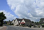
Neerijnen
Former municipalities of GelderlandGelderland geography stubsMunicipalities of the Netherlands disestablished in 2019Pages including recorded pronunciationsPages with Dutch IPA ... and 2 more
Populated places in GelderlandWest Betuwe

Neerijnen (Dutch pronunciation: [neːˈrɛinə(n)] ) is a village and former municipality in the Netherlands. It is about 35 kilometres (22 mi) south of Utrecht and some 15 kilometres (9.3 mi) north of 's-Hertogenbosch. On 1 January 2019, it merged with Geldermalsen and Lingewaal to form the new municipality of West Betuwe.
Excerpt from the Wikipedia article Neerijnen (License: CC BY-SA 3.0, Authors, Images).Neerijnen
van Pallandtweg, West Betuwe
Geographical coordinates (GPS) Address Nearby Places Show on map
Geographical coordinates (GPS)
| Latitude | Longitude |
|---|---|
| N 51.833333333333 ° | E 5.2833333333333 ° |
Address
van Pallandtweg
van Pallandtweg
4182 CB West Betuwe
Gelderland, Netherlands
Open on Google Maps


