place

Schenley Quadrangle

Henry Hornbostel buildingsHistoric district contributing properties in PennsylvaniaNRHP infobox with nocatNational Register of Historic Places in PittsburghPittsburgh History & Landmarks Foundation Historic Landmarks
University and college buildings on the National Register of Historic Places in PennsylvaniaUniversity and college dormitories in the United StatesUniversity of Pittsburgh residence halls
SchenleyQuadfromForbesl

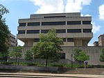
Schenley Quadrangle is a cluster of University of Pittsburgh ("Pitt") residence halls that is a Pittsburgh History and Landmarks Foundation Historic Landmark and are contributing properties to the Schenley Farms National Historic District in Pittsburgh, Pennsylvania, United States. The five residence halls are the former historic Schenley Apartments, designed by Henry Hornbostel with collaboration from Rutan & Russell and Eric Fisher Wood, for developer Franklin Nicola; they were built between 1922 and 1924 at a cost of more than $4.5 million ($71.6 million in 2021 dollars). Originally, the Schenley Apartments were home of Pittsburgh's well-to-do (including for a time their architect Henry Hornbostel) and consisted of 1,113 rooms in 238 apartments across the five buildings. The University acquired them in December 1955 at a cost of $3 million ($30.3 million in 2021 dollars), renovating them into residence halls for another $1 million ($9.97 million in 2021 dollars). By 1957-1958, 101 female students had moved into 20 apartments in Building F (now called Brackenridge Hall).Today, Schenley Quadrangle consists of five Pitt residence halls: Amos Hall, Brackenridge Hall, Bruce Hall, Holland Hall, and McCormick Hall. Previously a vehicle drop-off area and parking lot, the courtyard between these buildings was converted to a public open space with landscaping and exterior furniture in 2018; a raised platform was built for performances or other events. The renovation cost $5 million, with another $5 million spent on the parking garage beneath it.

Excerpt from the Wikipedia article Schenley Quadrangle (License: CC BY-SA 3.0, Authors, Images).

Schenley Quadrangle
Schenley Quad, Pittsburgh

Geographical coordinates (GPS) Address External links Nearby Places
placeShow on map

Wikipedia: Schenley QuadrangleContinue reading on Wikipedia

Geographical coordinates (GPS)

Latitude Longitude
N 40.443233333333 ° E -79.955775 °
placeShow on map

Address

Amos Hall

Schenley Quad
15260 Pittsburgh
Pennsylvania, United States
mapOpen on Google Maps

linkWikiData (Q7431181)
linkOpenStreetMap (154428331)

SchenleyQuadfromForbesl
Share experience

Nearby Places

Schenley Farms Historic District

The Schenley Farms Historic District, also referred to as the Schenley Farms–Oakland Civic District, is a historic district listed on the National Register of Historic Places that is located in the Oakland section of Pittsburgh, Pennsylvania, United States. It comprises two separately designated City of Pittsburgh historic districts: the Oakland Civic Center Historic District consisting of publicly and privately owned institutional buildings, and the adjacent Schenley Farms Historic District consisting mainly of a planned residential development of the early 20th Century. The Schenley Farms Historic District is roughly bounded by Forbes Avenue including the Carnegie Museums of Pittsburgh on the south; South Dithridge and North Bellefield on the east, extending to include St. Paul's Cathedral and Rectory on Fifth Avenue and North Craig Street; Bigelow Boulevard, Andover Road, and Bryn Mawr Road on the northwest; and Thackeray Street through to Fifth Avenue on the southwest. Noted for its late 19th And 20th Century Revivals architecture, it is home to a large portion of the campus of the University of Pittsburgh. The district comprises 154 contributing buildings, 31 of which are cultural or institutional buildings and 123 of which are residences in the northwest portion of the district. The historic district is a noted example of community planning and development following the City Beautiful movement that guided city planning and urban design in the United States from the mid-1890s through the first decade of the 20th century. The City Beautiful movement favored boulevards, parks, and formal civic buildings in the beaux-arts style. In 1905, Franklin Nicola put forth a development plan in the City Beautiful style for Oakland, which included civic, social, residential, and educational zones along Bigelow Boulevard which ran through the heart of the neighborhood. The proposal centered on a series of monumental buildings created in styles evoking ancient Greece and the Italian Renaissance. Although Nicola's plan was not fully implemented, including a never-constructed Oakland town hall, it produced such landmarks as the Soldiers and Sailors Memorial Hall, the Masonic Temple (now the University of Pittsburgh's Alumni Hall), and the Pittsburgh Athletic Association. Other major landmark buildings were added to the historic district after the pursuit of Nicola's designs had ended, including the landmark Cathedral of Learning and Heinz Memorial Chapel of the University of Pittsburgh and Mellon Institute. Contributing buildings in the historic district date from 1880 to 1979. A contributing building, the University Place Office Building, was razed in 2011.