place

Air India Flight 101

1966 in FranceAccidents and incidents involving the Boeing 707Air India accidents and incidentsAirliner accidents and incidents involving controlled flight into terrainAviation accidents and incidents in 1966
Aviation accidents and incidents in FranceEngvarB from July 2014January 1966 events in EuropeMont Blanc
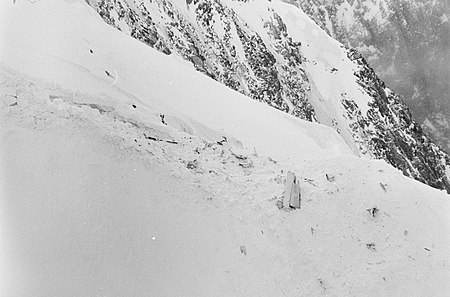
Air India Flight 101 VT DMN crashsite

Air India Flight 101 was a scheduled Air India passenger flight from Bombay to London, via Delhi, Beirut, and Geneva. On the morning of 24 January 1966 at 8:02 CET, on approach to Geneva, the Boeing 707 operating the flight accidentally flew into Mont Blanc in France, killing all 117 people on board. Among the victims was Dr. Homi Jehangir Bhabha, the founder and chairman of the Atomic Energy Commission of India.The crash occurred just a few hundred feet away from where an Air India Lockheed 749 Constellation operating Air India Flight 245 on a charter flight, had crashed in 1950.

Excerpt from the Wikipedia article Air India Flight 101 (License: CC BY-SA 3.0, Authors, Images).

Air India Flight 101
The Grand Mulets, Bonneville

Geographical coordinates (GPS) Address Nearby Places
placeShow on map

Wikipedia: Air India Flight 101Continue reading on Wikipedia

Geographical coordinates (GPS)

Latitude Longitude
N 45.877777777778 ° E 6.8666666666667 °
placeShow on map

Address

The Grand Mulets

The Grand Mulets
74400 Bonneville
Auvergne-Rhône-Alpes, France
mapOpen on Google Maps

Air India Flight 101 VT DMN crashsite
Share experience

Nearby Places

Bossons Glacier
Bossons Glacier

The Bossons Glacier is one of the larger glaciers of the Mont Blanc massif of the Alps, found in the Chamonix valley of Haute-Savoie département, south-eastern France. It is fed from icefields lying on the northern side of Mont Blanc, and descends down close to the Aiguille du Midi and ends on the southern side of the Arve valley, close to the town of Chamonix. It has the largest altitudinal drop of all the alpine glaciers in Europe, and formerly extended much further down the valley than it does today. It is now approximately 7.5 km long, with a surface area of approximately 10 km². In the 17th century the Bossons glacier extended right down into Chamonix, reaching the settlement of Le Fouly, engulfing farmland, barns and houses. Local bishops were called upon to exorcise the demons within the glacier. In 1777 the traveller and correspondent, William Coxe, observed in his letters that "we mounted by the side of the glacier of Bosson, to les Murailles de Glace, so called from their resemblance to walls: they form the large ranges of ice of prodigious thickness and solidity, rising abruptly and parallel to each other. Some of these ranges appeared about a hundred feet high. Near them were pyramids and cone of ice of all forms and sizes, shooting to a very considerable height, in the most beautiful and fantastic shapes." He then noted that, on his return in 1785, "these murailles de glace no longer existed".: 781  By around 1784 the glacier had started to retreat, although there was a renewed surge around 1815 and the frightened community erected a cross in front of its snout, which served as a marker for glacial retreat for the next 100 years.In 1900 the snout of the glacier was still reaching down into the valley bottom at an altitude of 1,050 metres above sea level. By 1980 the snout only reached down to about 1,200 metres, and by 2008 it had melted backwards even further backwards, ended at around 1,400 metres, albeit still well below the treeline. A series of paintings from the early 19th century and modern day photographs reveal the extent of the glacier's recession as the climate has warmed, as well as revealing evidence of glacial moraines showing its past extent down to the valley bottom.