Rhencullen
All image captions for cleanupImage captions for cleanup/Without examplesImage captions for cleanup from November 2019Isle of Man stubsRoads in the Isle of Man ... and 1 more
Use British English from October 2017
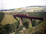
Rhencullen (Manx: ‘holly ridge’) (locally ) including Birkin's Bend is situated adjacent to the 17th milestone of the TT course, on the primary A3 Castletown to Ramsey road in the Isle of Man.
Excerpt from the Wikipedia article Rhencullen (License: CC BY-SA 3.0, Authors).Rhencullen
A3, Michael
Geographical coordinates (GPS) Address Nearby Places Show on map
 Continue reading on Wikipedia
 Geographical coordinates (GPS)
| Latitude | Longitude |
|---|---|
| N 54.293388888889 ° | E -4.5771111111111 ° |
Address
A3
Michael
Isle of Man
Open on Google Maps