St. John's Park
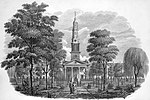
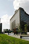
St. John's Park was a 19th-century park and square, and the neighborhood of townhouses around it, in what is now the Tribeca neighborhood of Lower Manhattan, New York City. The square was bounded by Varick Street, Laight Street, Hudson Street and Beach Street, now also known for that block as Ericsson Place. Although the name "St. John's Park" is still in use, it is no longer a park and is inaccessible to the public.The land was part of a plantation owned by an early settler to New Netherland and was later owned by the English Crown, who deeded it to Trinity Church. The church built St. John's Chapel and laid out "Hudson Square", creating New York City's first development of townhouses around a private park. By 1827 the neighborhood had become known as "St. John's Park" and remained fashionable until about 1850. In 1866 it was sold to Cornelius Vanderbilt's Hudson River Railway Company and became the location of St. John's Park Freight Depot, the railroad's southern terminus. The terminal was demolished in 1927 to allow construction of exits from the Port Authority of New York and New Jersey's Holland Tunnel.
Excerpt from the Wikipedia article St. John's Park (License: CC BY-SA 3.0, Authors).St. John's Park
I 78, New York Manhattan
Geographical coordinates (GPS) Address Nearby Places Show on map
Geographical coordinates (GPS)
| Latitude | Longitude |
|---|---|
| N 40.7212 ° | E -74.0075 ° |
Address
I 78
10005 New York, Manhattan
New York, United States
Open on Google Maps


