place

Clapham, Bedfordshire

Bedfordshire geography stubsBorough of BedfordCivil parishes in BedfordshireClapham, BedfordshireUse British English from July 2016
Villages in Bedfordshire
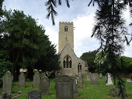
Church, Clapham (geograph 3635720)

Clapham is a village and civil parish in the Borough of Bedford in Bedfordshire, England. It had a population of 3,643 as at the 2001 census, increasing to 4,560 at the 2011 Census.

Excerpt from the Wikipedia article Clapham, Bedfordshire (License: CC BY-SA 3.0, Authors, Images).

Clapham, Bedfordshire
George Street,

Geographical coordinates (GPS) Address Nearby Places
placeShow on map

Wikipedia: Clapham, BedfordshireContinue reading on Wikipedia

Geographical coordinates (GPS)

Latitude Longitude
N 52.164892 ° E -0.501964 °
placeShow on map

Address

George Street

George Street
MK41 6BT , Clapham
England, United Kingdom
mapOpen on Google Maps

Church, Clapham (geograph 3635720)
Share experience

Nearby Places

Oakley railway station (Bedfordshire)

Oakley railway station was built by the Midland Railway in 1857 on its extension from Leicester to Bedford and Hitchin. It was closed to passengers in 1958 and closed completely in 1963. The station buildings remain in a dilapidated state though the goods yard is used by a haulage company. There are also a set of railway houses the opposite side of the line from the station building which were constructed between 1883 and 1901 as accommodation for railway workers which remain extant. About a mile (2 km) north of the station is the point where the Midland installed its first troughs to allow locomotives to pick up water. The river valley here is very flat, and the line crosses it seven times in the space of about 7 miles (11 km) most prominently on the viaduct (which is two separate viaducts running parallel to each other) to the north of the village. The line is elevated because of problems with flooding. Even the local roads have raised walkways.Croxhall opened in 1840 by the Birmingham and Derby Junction Railway was previously known as Oakley but was renamed on 1 December previously.Two fatal railway accidents occurred around Oakley. One occurred on 21 January 1938 at the Junction between the Midland Main Line and the Bedford–Northampton line to the south of the village, when an Express train collided with an empty stock movement killing three and injuring eight. The other accident occurred 4 October 1949 on the viaduct that takes the Midland Main Line over the River Great Ouse to the north of the village, where a goods train collided with a stationary goods train on the viaduct, driving the goods train off of the viaduct and into a meadow, blocking the goods lines on the viaduct and killing the driver and the fireman.

Milton Ernest
Milton Ernest

Milton Ernest is a village and civil parish in Bedfordshire, England, about 5 miles (8.0 km) north of Bedford itself. It had a population of 754 in 2001. This had risen to 761 according to the 2011 census. The village is situated on the east bank of the River Great Ouse, and is the site of Milton Ernest Hall, which was used as the United States Eighth Air Force's support command headquarters in the Second World War.The village is named in the Domesday Book in the hundred of Stodden. The entry reads: "Middletone / Mildentone: Miles Crispin and William Basset from Hugh de Beauchamp; Thorgils from Nigel d'Aubigny; Reginald from Walter of Flanders; Ivo, Hugh de Grandmesnil's steward from Adelaide, Hugh de Grandmesnil's wife; a beadle from the king. Mill."All Saints' Church was built between the 12th and 15th centuries.Possible variations in spelling may include "Milton Harneys", in 1396, & "Midelton Erneys", in 1430. The first half of the name means "Middle Farm". The second half of the name is derived from the name of the main manor of the village and was added in the 13th century to distinguish it from Bedfordshire's other Milton (Bryant). Milton Ernest has a small voluntary controlled village school, closely linked to the church, that has between 60 and 65 pupils drawn from this and surrounding villages. The secondary school for the area is Sharnbrook Academy, in the village of Sharnbrook, located around 3 miles (4.8 km) away. On 15 December 1944, Glenn Miller took off from RAF Twinwood Farm, in neighbouring Clapham, on his last, ill-fated flight, and was last seen in public in the Queen's Head Hotel in Milton Ernest before he disappeared. A plaque at Milton Ernest Hall honours Major Glenn Miller and members of the United States Eighth Air Force, it reads "In memory of all the personnel who served in World War II at Milton Ernest Hall headquarters USAAF Eight Air Force Service Command Station 608 1943-1946, also Major Glenn Miller & the band of the Allied Expeditionary Force who were stationed here from July to December 1944". The controversial Yarl's Wood Immigration Removal Centre is located in the parish. Milton Ernest is also home to the UK's first indoor skydiving and indoor surfing facilities. However both have now ceased operations. A book entitled "The Importance of Milton Ernest" was published by David Newman and details the above and much more of Milton Ernest history and prominence