place

Stratford St. Mary

Babergh DistrictCivil parishes in SuffolkEngvarB from June 2016Flint buildingsVillages in Suffolk
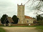
Stratford St Mary church April 2005

Stratford St. Mary is a village in Suffolk, England in the heart of 'Constable Country'. John Constable painted a number of paintings in and around Stratford. Stratford (the ford of the Roman Via Strata) with its attached hamlet of Higham sits on the Suffolk/Essex border on the River Stour, Suffolk. It is 58 miles (93 km) from London just off the A12 between Colchester and Ipswich. The village has a fifteenth-century flint faced church which is clearly visible from the A12. It is also served by a primary school, post office and village store, and three pubs. Stratford village is within the Stratford Vale which is also recognised as an area of outstanding natural beauty.

Excerpt from the Wikipedia article Stratford St. Mary (License: CC BY-SA 3.0, Authors, Images).

Stratford St. Mary
Essex Way, Colchester Langham

Geographical coordinates (GPS) Address Nearby Places
placeShow on map

Wikipedia: Stratford St. MaryContinue reading on Wikipedia

Geographical coordinates (GPS)

Latitude Longitude
N 51.967 ° E 0.967 °
placeShow on map

Address

Essex Way

Essex Way
CO4 5PS Colchester, Langham
England, United Kingdom
mapOpen on Google Maps

Stratford St Mary church April 2005
Share experience

Nearby Places

Shelley, Suffolk
Shelley, Suffolk

Shelley is a small village and civil parish in Suffolk, England. Located on the west bank of the River Brett around three miles south of Hadleigh, it is part of Babergh district. The population of the village was only minimal at the 2011 Census and is included in the civil parish of Higham. Most of the parish is within the Dedham Vale Area of Outstanding Natural Beauty. Other points of interest are Shelley Hall, a listed building with a protected moat, once owned by the Partridge family, and Snakes Wood, which is classified as Ancient Woodland and serves as a nature reserve. The village is first recorded before the Norman conquest in the S1051 charter of 1000AD in the will of Ælfflæd. The Domesday Book of 1086 records the population of Shelley in 1086 to be 42 households along with 8 cattle, 32 pigs, 200 sheep, 3 other animals, 28 acres of meadow, 1,000 woodland pigs, two mills.Barker writes that there is an unusually long hedge in Shelley made up of coppiced lime trees. He writes that this follows the boundaries of remnants of nineteenth-century clearances of some of the ancient forest. Hedges of this sort are known as assart hedges.Elizabeth Gosnold Tilney, sister of Jamestown colonist and explorer Bartholomew Gosnold, is buried at All Saints' Church, Shelley. An attempt was made to use DNA from her supposed remains to confirm the identity of the body of her brother in Jamestown, but it was inconclusive as it could not be confirmed which body was hers.