place

Leaveland

Borough of SwaleCivil parishes in KentVillages in Kent
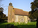
St Laurence, Leaveland geograph.org.uk 395483

Leaveland is a hamlet and civil parish located in the Swale borough of Kent, South East England. In terms of topography, it is described as a "village surrounded by inhabited countryside", and is situated mostly on high ground. It is located 5 miles South of Faversham, West of Badlesmere, and on or close to the A251.The closest railway station to the area is Selling, which is just over three miles away, although Faversham station is more accessible and offers better services. The closest estuary is The Swale which separates the Isle of Sheppey from mainland Kent, and flows to the north of Faversham Creek.. Leaveland itself covers an area of 1.5 km2 and lies entirely within the Kent Downs Area of Outstanding Natural Beauty. According to the 2011 Census there were 54 males and 46 females living in the parish.Leaveland as a civil parish is too small to have its own parish council, therefore Sheldwich, Badlesmere and Leaveland have a combined parish council (their total population is 759), consisting of 8 members. They have monthly meetings where by they deal with local issues, help aid council spending, and provide information to organisations who operate in the area. Leaveland is also part of Swale Borough Council, as part of the 4 towns in the borough. These include Faversham, Sittingbourne, Sheerness and Queenborough. The Borough currently has 47 councillors, no one party holds a majority (2019 elections)

Excerpt from the Wikipedia article Leaveland (License: CC BY-SA 3.0, Authors, Images).

Leaveland
Ashford Road, Borough of Swale

Geographical coordinates (GPS) Address Nearby Places
placeShow on map

Wikipedia: LeavelandContinue reading on Wikipedia

Geographical coordinates (GPS)

Latitude Longitude
N 51.2575 ° E 0.872 °
placeShow on map

Address

Ashford Road
ME13 0NW Borough of Swale
England, United Kingdom
mapOpen on Google Maps

St Laurence, Leaveland geograph.org.uk 395483
Share experience

Nearby Places

Badlesmere, Kent
Badlesmere, Kent

Badlesmere is a village and civil parish in the Swale district of Kent, England, about five miles south of Faversham and eight miles north of Ashford on the A251. It was once called Basmere. There has been a recorded settlement (under the name 'Badelesmere') as far back as the Domesday Book. Which also mentioned that in the time of King Edward the Confessor, the parish was worth sixty shillings. The manor was previously owned by Odo, Earl of Kent (as the Bishop of Bayeux), but following his trial (for fraud) in 1076 his assets were re-apportioned, including Badlesmere. The abbot of St. Augustine's then claimed this manor.During the reign of King Richard I of England (1189–1199), the manor was held by Guncelin Badlesmere, who had accompanied the king during his Siege of Acre in Palestine. The manor passed through several generations of the Badlesmere family, including Guncelin Badlesmere (died 1301), who was Justice of Chester and his son Bartholomew Badlesmere, 1st Baron (died 1322), who was governor of Leeds Castle. He obtained the king's licence to found a priory on his lands but nothing came of it.In 1523, Sir Thomas Randolph (an eminent statesman during the reign Queen Elizabeth I), was born here.The church, dedicated to St Leonard, is a grade II* listed Anglican church, described as "interesting as a small, quite unremarkable church" which was not 'restored' in the Victorian era. Its interior is 13th century and 18th century. It has a complete set of Georgian box pews. In 1887, J.C.L. Stahlschmidt reported that the bell hanging in the church was one of those made in 1635 by Joseph Hatch for St Mary's Church, Reculver; the church at Reculver was demolished in 1809.The village green, known as Badlesmere Lees, lies off the main road between the towns of Faversham and Ashford. The parish has been linked for many years with that of Leaveland, whose mediaeval church (built in 1222) is very different from Badlesmere. It has a crown-post roof and a 16th-century monument to a local family survived the Victorian restoration. The village forms part of the civil parish of Sheldwich, Badlesmere and Leaveland.

Challock
Challock

Challock is a mostly wooded, large village and civil parish in the Borough of Ashford, Kent, England. The village name derives from the old English 'Cealfloca' - calf enclosure. A clear nucleus of the village is centred 8 miles (13 km) south of the port of Faversham and 5 miles (8.0 km) north of Ashford. It dates from around AD823. Challock contains a boundary to one of the highest points on the North Downs: the 700-foot (210 m) contour is close to the village centre. Snowfall in January and February is occasionally heavy, when counter-prevailing north-easterly winds exist in those months. Challock is at the crossroads of two major roads: the A251 from Ashford to Faversham, and the A252, which links Maidstone to Canterbury. Prior to the construction of a roundabout, the crossroads was a notorious accident hotspot for drivers coming from Chilham and Ashford, due in part to the Halfway House public house which stands close to the corner.William the Conqueror gave the manor of Challock to Battle Abbey, and it remained in the Abbey's possession until the dissolution of the monasteries by Henry VIII in the 16th century. A smock mill stood to the north of the village until 1906 when it was destroyed by a storm - the mill had not been working for many years prior to this event. The parish church is dedicated to Saints Cosmas and Damian; it has fine wall paintings by celebrated local artist John Ward and his friend Gordon Davies. There is also a Methodist chapel in the village. A Goose Fair is held in September each year. The showjumper William Funnell was born and raised in the village.