place

Greenwich, Connecticut

1640 establishments in ConnecticutGreenwich, ConnecticutPopulated coastal places in ConnecticutPopulated places established in 1640Towns in Connecticut
Towns in Fairfield County, ConnecticutTowns in the New York metropolitan area
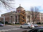
Greenwich (CT) Town Hall

Greenwich (, GREN-itch) is a town in southwestern Fairfield County, Connecticut, United States. At the 2020 census, the town had a total population of 63,518. The largest town on Connecticut's Gold Coast, Greenwich is home to many hedge funds and other financial services firms. Greenwich is a principal community of the Bridgeport–Stamford–Norwalk–Danbury metropolitan statistical area, which comprises all of Fairfield County. Greenwich is the southernmost and westernmost municipality in Connecticut as well as in the six-state region of New England. The town is named after Greenwich, a royal borough of London in the United Kingdom.

Excerpt from the Wikipedia article Greenwich, Connecticut (License: CC BY-SA 3.0, Authors, Images).

Greenwich, Connecticut
Hillside Road,

Geographical coordinates (GPS) Address Phone number Website Nearby Places
placeShow on map

Wikipedia: Greenwich, ConnecticutContinue reading on Wikipedia

Geographical coordinates (GPS)

Latitude Longitude
N 41.038888888889 ° E -73.613611111111 °
placeShow on map

Address

Greenwich High School

Hillside Road 10
06830
Connecticut, United States
mapOpen on Google Maps

Phone number

call2036258000

Website
greenwichschools.org

linkVisit website

Greenwich (CT) Town Hall
Share experience

Nearby Places

Strickland Road Historic District

The Strickland Road Historic District of Greenwich, Connecticut is a 9-acre (3.6 ha) historic district that was listed on the U.S. National Register of Historic Places in 1990. The district extends along Strickland Road in the Cos Cob section of Greenwich, between its junction River Road in the south, to just north of its junction with Loughlin Road in the north. It represents a well-preserved cross-section of residential architecture dating coverint a 200-year period, from about 1740 to 1934. It includes the c. 1730 Bush-Holley House, a historic house museum which is a National Historic Landmark for it role in the Cos Cob art colony. There are 28 primary contributing buildings in the district. Most of the buildings are wood-frame structures between one and three stories in height; the notable exceptions are two of the later houses, which are Tudor Revival in style and have brick and stucco exteriors.The Cos Cob area was settled in the 17th century as a colonial maritime community, at first by Dutch settlers (as part of New Netherland) and later by English settlers. The Strickland Road area was known as the Lower Landing, and flourished in the 18th century, particularly through the efforts of David Bush, the Dutch builder of the Bush-Holley House. It was primarily a transportation center, with packet boats serving other area ports, and some of the finer houses on Strickland Road were built by sea captains. The area declined in importance after the packet boats were supplanted by the railroad in the mid-19th century, and became a residential enclave. Its last major industrial site, a tidal grist mill, burned in 1899. Most of the buildings in the district date to the early 20th century, in the Bungalow and Tudor Revival styles popular at that time.