Carbondale, Colorado

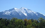
The Town of Carbondale is a home rule municipality located in Garfield County, Colorado, United States. The town population was 6,434 at the 2020 United States Census. Carbondale is a part of the Glenwood Springs, CO Micropolitan Statistical Area. The town is located in the Roaring Fork Valley, downstream from Aspen and upstream from the mouth of the Roaring Fork River at Glenwood Springs. The town proper sits on the south bank of the river, near its confluence with the Crystal River. Carbondale's horizon is dominated by the 12,953 ft (3,952 m) tall Mount Sopris several miles to the south of town. Carbondale is the northern terminus of the West Elk Loop Scenic and Historic Byway.
Excerpt from the Wikipedia article Carbondale, Colorado (License: CC BY-SA 3.0, Authors, Images).Carbondale, Colorado
Graceland Drive,
Geographical coordinates (GPS) Address Nearby Places Show on map
 Continue reading on Wikipedia
 Geographical coordinates (GPS)
| Latitude | Longitude |
|---|---|
| N 39.395 ° | E -107.21472222222 ° |
Address
Graceland Drive 2742
Colorado, United States
Open on Google Maps