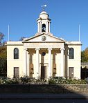
Lord's tube station
Disused London Underground stationsDisused railway stations in the City of WestminsterFormer Metropolitan Railway stationsHistory of the City of WestminsterMetropolitan line stations ... and 4 more
Railway stations in Great Britain closed in 1939Railway stations in Great Britain opened in 1868St John's WoodUse British English from January 2018

Lord's was a London Underground station located in St John's Wood, north-west London. It was opened in 1868 by the Metropolitan Railway on its Metropolitan and St John's Wood Railway line, which is now part of the Underground's Metropolitan line. It was known by several different names throughout its history; by the time of its closure in 1939 its name was taken from the nearby Lord's Cricket Ground.
Excerpt from the Wikipedia article Lord's tube station (License: CC BY-SA 3.0, Authors, Images).Lord's tube station
St John's Wood Road, City of Westminster St. John's Wood
Geographical coordinates (GPS) Address Nearby Places Show on map
Geographical coordinates (GPS)
| Latitude | Longitude |
|---|---|
| N 51.53 ° | E -0.16916666666667 ° |
Address
St John's Wood Road
St John's Wood Road
NW8 7HT City of Westminster, St. John's Wood
England, United Kingdom
Open on Google Maps


